You are here: Home > Network List > TA - USArray Transportable Network (new EarthScope stations) Stations List
> Station Q19A Hogan Spring (BLM), Cisco, UT, USA > Earthquake Result Viewer
Q19A Hogan Spring (BLM), Cisco, UT, USA - Earthquake Result Viewer
| Earthquake location: |
Near Coast Of Guatemala |
| Earthquake latitude/longitude: |
13.6/-90.6 |
| Earthquake time(UTC): |
2008/04/15 (106) 03:03:04 GMT |
| Earthquake Depth: |
33 km |
| Earthquake Magnitude: |
5.6 MB, 5.8 MS, 6.1 MW, 6.1 MW |
| Earthquake Catalog/Contributor: |
WHDF/NEIC |
|
| Network: |
TA USArray Transportable Network (new EarthScope stations) |
| Station: |
Q19A Hogan Spring (BLM), Cisco, UT, USA |
| Lat/Lon: |
38.96 N/109.26 W |
| Elevation: |
1283 m |
|
| Distance: |
30.2 deg |
| Az: |
330.262 deg |
| Baz: |
141.78 deg |
| Ray Param: |
0.07936368 |
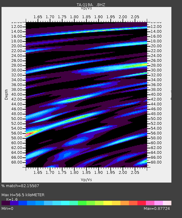
| Estimated Moho Depth: |
56.5 km |
| Estimated Crust Vp/Vs: |
1.60 |
| Assumed Crust Vp: |
6.291 km/s |
| Estimated Crust Vs: |
3.932 km/s |
| Estimated Crust Poisson's Ratio: |
0.18 |
|
| Radial Match: |
82.15587 % |
| Radial Bump: |
374 |
| Transverse Match: |
62.52031 % |
| Transverse Bump: |
400 |
| SOD ConfigId: |
2504 |
| Insert Time: |
2010-03-06 05:55:47.062 +0000 |
| GWidth: |
2.5 |
| Max Bumps: |
400 |
| Tol: |
0.001 |
|
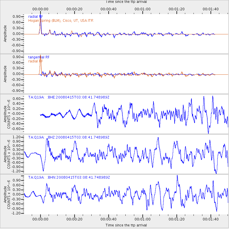
Signal To Noise
| Channel | StoN | STA | LTA |
| TA:Q19A: :BHZ:20080415T03:08:41.748989Z | 7.173953 | 7.067959E-7 | 9.852252E-8 |
| TA:Q19A: :BHN:20080415T03:08:41.748989Z | 3.109118 | 3.2695252E-7 | 1.0515925E-7 |
| TA:Q19A: :BHE:20080415T03:08:41.748989Z | 3.1123164 | 2.6767634E-7 | 8.600551E-8 |
| Arrivals |
| Ps | 5.9 SECOND |
| PpPs | 21 SECOND |
| PsPs/PpSs | 27 SECOND |


