You are here: Home > Network List > TA - USArray Transportable Network (new EarthScope stations) Stations List
> Station Q19A Hogan Spring (BLM), Cisco, UT, USA > Earthquake Result Viewer
Q19A Hogan Spring (BLM), Cisco, UT, USA - Earthquake Result Viewer
| Earthquake location: |
Central Mid-Atlantic Ridge |
| Earthquake latitude/longitude: |
7.3/-34.9 |
| Earthquake time(UTC): |
2008/05/23 (144) 19:35:34 GMT |
| Earthquake Depth: |
9.0 km |
| Earthquake Magnitude: |
6.0 MB, 6.4 MS, 6.5 MW, 6.5 MW |
| Earthquake Catalog/Contributor: |
WHDF/NEIC |
|
| Network: |
TA USArray Transportable Network (new EarthScope stations) |
| Station: |
Q19A Hogan Spring (BLM), Cisco, UT, USA |
| Lat/Lon: |
38.96 N/109.26 W |
| Elevation: |
1283 m |
|
| Distance: |
73.3 deg |
| Az: |
308.374 deg |
| Baz: |
94.119 deg |
| Ray Param: |
0.053106945 |
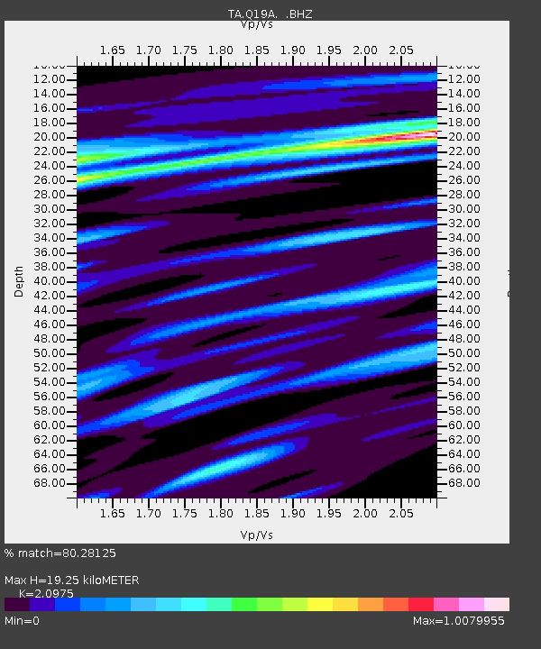
| Estimated Moho Depth: |
19.25 km |
| Estimated Crust Vp/Vs: |
2.10 |
| Assumed Crust Vp: |
6.291 km/s |
| Estimated Crust Vs: |
2.999 km/s |
| Estimated Crust Poisson's Ratio: |
0.35 |
|
| Radial Match: |
80.28125 % |
| Radial Bump: |
400 |
| Transverse Match: |
84.49672 % |
| Transverse Bump: |
400 |
| SOD ConfigId: |
2504 |
| Insert Time: |
2010-03-06 05:55:57.712 +0000 |
| GWidth: |
2.5 |
| Max Bumps: |
400 |
| Tol: |
0.001 |
|
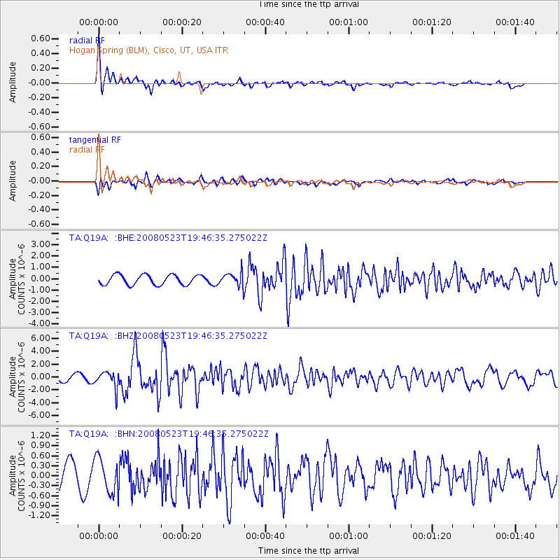
Signal To Noise
| Channel | StoN | STA | LTA |
| TA:Q19A: :BHZ:20080523T19:46:35.275022Z | 2.8683288 | 1.3066815E-6 | 4.5555498E-7 |
| TA:Q19A: :BHN:20080523T19:46:35.275022Z | 1.3833493 | 5.249192E-7 | 3.7945526E-7 |
| TA:Q19A: :BHE:20080523T19:46:35.275022Z | 1.4305058 | 6.2708597E-7 | 4.383666E-7 |
| Arrivals |
| Ps | 3.5 SECOND |
| PpPs | 9.2 SECOND |
| PsPs/PpSs | 13 SECOND |


