You are here: Home > Network List > CI - Caltech Regional Seismic Network Stations List
> Station BBR Big Bear Solar Observatory > Earthquake Result Viewer
BBR Big Bear Solar Observatory - Earthquake Result Viewer
| Earthquake location: |
Central Mid-Atlantic Ridge |
| Earthquake latitude/longitude: |
8.0/-39.2 |
| Earthquake time(UTC): |
2007/08/20 (232) 22:42:29 GMT |
| Earthquake Depth: |
10 km |
| Earthquake Magnitude: |
6.3 MB, 6.4 MS, 6.5 MW |
| Earthquake Catalog/Contributor: |
WHDF/NEIC |
|
| Network: |
CI Caltech Regional Seismic Network |
| Station: |
BBR Big Bear Solar Observatory |
| Lat/Lon: |
34.26 N/116.92 W |
| Elevation: |
2069 m |
|
| Distance: |
75.3 deg |
| Az: |
303.246 deg |
| Baz: |
90.203 deg |
| Ray Param: |
0.051730227 |
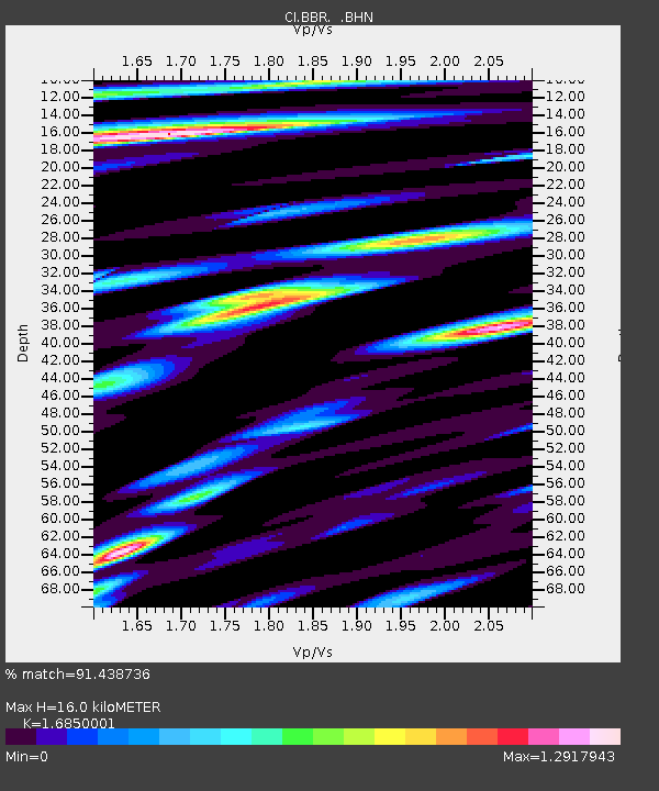
| Estimated Moho Depth: |
16.0 km |
| Estimated Crust Vp/Vs: |
1.69 |
| Assumed Crust Vp: |
6.276 km/s |
| Estimated Crust Vs: |
3.725 km/s |
| Estimated Crust Poisson's Ratio: |
0.23 |
|
| Radial Match: |
91.438736 % |
| Radial Bump: |
400 |
| Transverse Match: |
83.179054 % |
| Transverse Bump: |
400 |
| SOD ConfigId: |
2564 |
| Insert Time: |
2010-02-26 01:35:30.297 +0000 |
| GWidth: |
2.5 |
| Max Bumps: |
400 |
| Tol: |
0.001 |
|

Signal To Noise
| Channel | StoN | STA | LTA |
| CI:BBR: :BHN:20070820T22:53:41.33802Z | 0.8455898 | 3.7335107E-7 | 4.415274E-7 |
| CI:BBR: :BHE:20070820T22:53:41.33802Z | 1.4319142 | 6.0073455E-7 | 4.1953248E-7 |
| CI:BBR: :BHZ:20070820T22:53:41.33802Z | 2.2754266 | 9.543998E-7 | 4.1943773E-7 |
| Arrivals |
| Ps | 1.8 SECOND |
| PpPs | 6.6 SECOND |
| PsPs/PpSs | 8.4 SECOND |


