You are here: Home > Network List > TA - USArray Transportable Network (new EarthScope stations) Stations List
> Station I28M Miner Creek, YT, CAN > Earthquake Result Viewer
I28M Miner Creek, YT, CAN - Earthquake Result Viewer
| Earthquake location: |
Tonga Islands |
| Earthquake latitude/longitude: |
-15.4/-173.2 |
| Earthquake time(UTC): |
2017/11/04 (308) 09:00:19 GMT |
| Earthquake Depth: |
10 km |
| Earthquake Magnitude: |
6.8 Mww |
| Earthquake Catalog/Contributor: |
NEIC PDE/us |
|
| Network: |
TA USArray Transportable Network (new EarthScope stations) |
| Station: |
I28M Miner Creek, YT, CAN |
| Lat/Lon: |
65.45 N/139.94 W |
| Elevation: |
1188 m |
|
| Distance: |
84.4 deg |
| Az: |
13.321 deg |
| Baz: |
212.14 deg |
| Ray Param: |
0.04552226 |
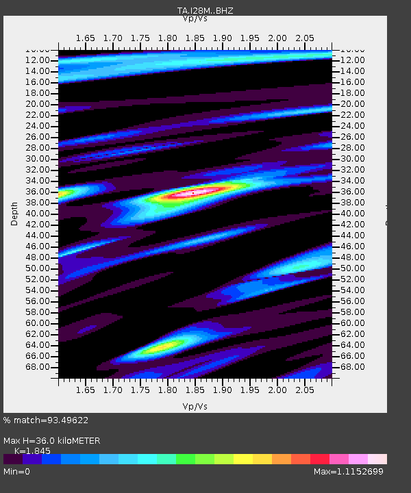
| Estimated Moho Depth: |
36.0 km |
| Estimated Crust Vp/Vs: |
1.85 |
| Assumed Crust Vp: |
6.566 km/s |
| Estimated Crust Vs: |
3.559 km/s |
| Estimated Crust Poisson's Ratio: |
0.29 |
|
| Radial Match: |
93.49622 % |
| Radial Bump: |
400 |
| Transverse Match: |
90.899254 % |
| Transverse Bump: |
400 |
| SOD ConfigId: |
13570011 |
| Insert Time: |
2019-04-29 02:39:29.561 +0000 |
| GWidth: |
2.5 |
| Max Bumps: |
400 |
| Tol: |
0.001 |
|

Signal To Noise
| Channel | StoN | STA | LTA |
| TA:I28M: :BHZ:20171104T09:12:20.074971Z | 37.518185 | 3.560101E-6 | 9.489001E-8 |
| TA:I28M: :BHN:20171104T09:12:20.074971Z | 10.72447 | 1.016377E-6 | 9.477178E-8 |
| TA:I28M: :BHE:20171104T09:12:20.074971Z | 7.483769 | 7.264964E-7 | 9.7076274E-8 |
| Arrivals |
| Ps | 4.7 SECOND |
| PpPs | 15 SECOND |
| PsPs/PpSs | 20 SECOND |


