You are here: Home > Network List > TA - USArray Transportable Network (new EarthScope stations) Stations List
> Station J25K Salcha River, AK, USA > Earthquake Result Viewer
J25K Salcha River, AK, USA - Earthquake Result Viewer
| Earthquake location: |
Tonga Islands |
| Earthquake latitude/longitude: |
-15.4/-173.2 |
| Earthquake time(UTC): |
2017/11/04 (308) 09:00:19 GMT |
| Earthquake Depth: |
10 km |
| Earthquake Magnitude: |
6.8 Mww |
| Earthquake Catalog/Contributor: |
NEIC PDE/us |
|
| Network: |
TA USArray Transportable Network (new EarthScope stations) |
| Station: |
J25K Salcha River, AK, USA |
| Lat/Lon: |
64.61 N/145.37 W |
| Elevation: |
949 m |
|
| Distance: |
82.5 deg |
| Az: |
11.719 deg |
| Baz: |
207.036 deg |
| Ray Param: |
0.046833076 |
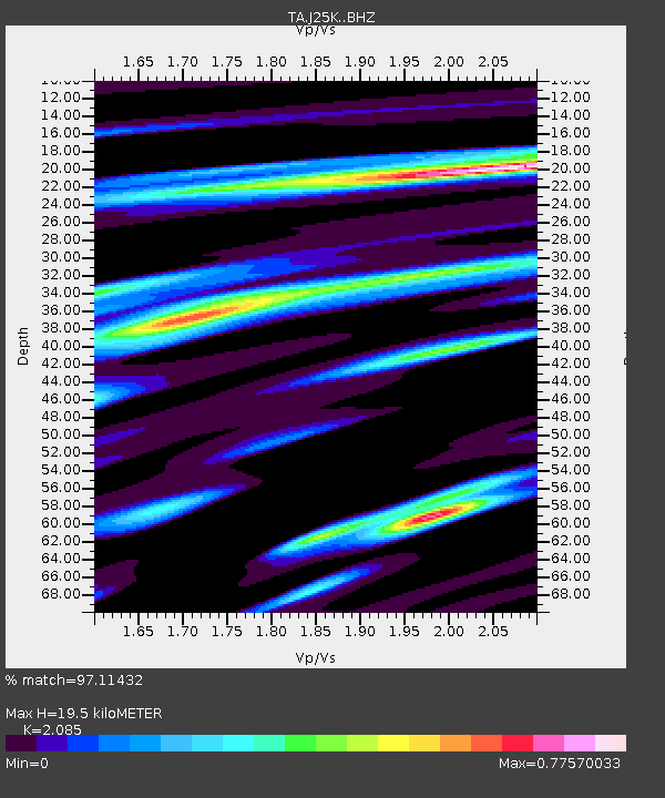
| Estimated Moho Depth: |
19.5 km |
| Estimated Crust Vp/Vs: |
2.09 |
| Assumed Crust Vp: |
6.566 km/s |
| Estimated Crust Vs: |
3.149 km/s |
| Estimated Crust Poisson's Ratio: |
0.35 |
|
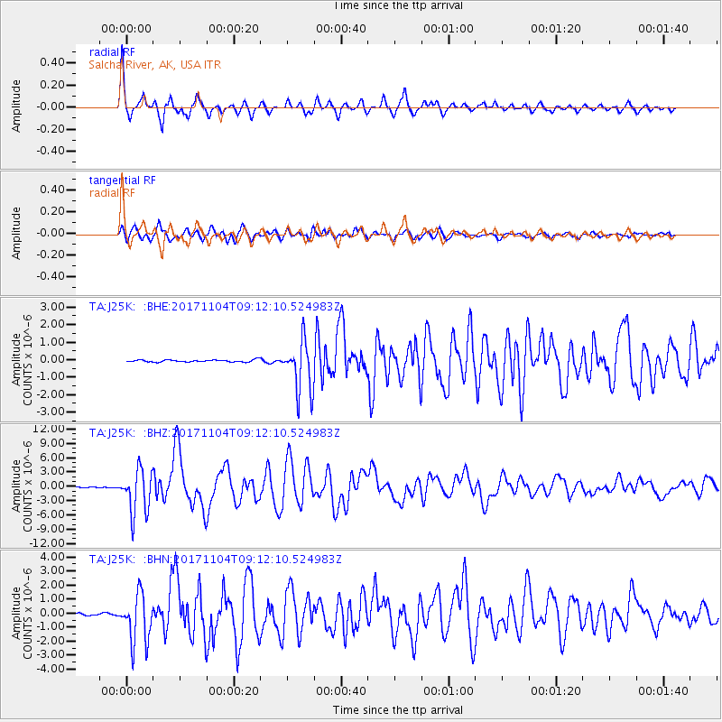
| Radial Match: |
97.11432 % |
| Radial Bump: |
375 |
| Transverse Match: |
92.653786 % |
| Transverse Bump: |
400 |
| SOD ConfigId: |
13570011 |
| Insert Time: |
2019-04-29 02:39:37.086 +0000 |
| GWidth: |
2.5 |
| Max Bumps: |
400 |
| Tol: |
0.001 |
|
Signal To Noise
| Channel | StoN | STA | LTA |
| TA:J25K: :BHZ:20171104T09:12:10.524983Z | 50.82283 | 4.6862237E-6 | 9.220706E-8 |
| TA:J25K: :BHN:20171104T09:12:10.524983Z | 23.648977 | 1.7657112E-6 | 7.466332E-8 |
| TA:J25K: :BHE:20171104T09:12:10.524983Z | 25.65381 | 1.6225614E-6 | 6.3248365E-8 |
| Arrivals |
| Ps | 3.3 SECOND |
| PpPs | 9.0 SECOND |
| PsPs/PpSs | 12 SECOND |


