You are here: Home > Network List > TA - USArray Transportable Network (new EarthScope stations) Stations List
> Station K20K Telida, AK, USA > Earthquake Result Viewer
K20K Telida, AK, USA - Earthquake Result Viewer
| Earthquake location: |
Tonga Islands |
| Earthquake latitude/longitude: |
-15.4/-173.2 |
| Earthquake time(UTC): |
2017/11/04 (308) 09:00:19 GMT |
| Earthquake Depth: |
10 km |
| Earthquake Magnitude: |
6.8 Mww |
| Earthquake Catalog/Contributor: |
NEIC PDE/us |
|
| Network: |
TA USArray Transportable Network (new EarthScope stations) |
| Station: |
K20K Telida, AK, USA |
| Lat/Lon: |
63.36 N/154.07 W |
| Elevation: |
548 m |
|
| Distance: |
79.9 deg |
| Az: |
8.64 deg |
| Baz: |
198.753 deg |
| Ray Param: |
0.048668075 |
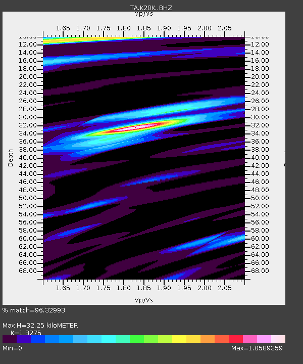
| Estimated Moho Depth: |
32.25 km |
| Estimated Crust Vp/Vs: |
1.83 |
| Assumed Crust Vp: |
6.438 km/s |
| Estimated Crust Vs: |
3.523 km/s |
| Estimated Crust Poisson's Ratio: |
0.29 |
|
| Radial Match: |
96.32993 % |
| Radial Bump: |
381 |
| Transverse Match: |
90.04338 % |
| Transverse Bump: |
400 |
| SOD ConfigId: |
13570011 |
| Insert Time: |
2019-04-29 02:39:41.975 +0000 |
| GWidth: |
2.5 |
| Max Bumps: |
400 |
| Tol: |
0.001 |
|

Signal To Noise
| Channel | StoN | STA | LTA |
| TA:K20K: :BHZ:20171104T09:11:56.474995Z | 53.07076 | 4.8492075E-6 | 9.137249E-8 |
| TA:K20K: :BHN:20171104T09:11:56.474995Z | 18.43228 | 1.393786E-6 | 7.561658E-8 |
| TA:K20K: :BHE:20171104T09:11:56.474995Z | 6.852615 | 8.16722E-7 | 1.1918399E-7 |
| Arrivals |
| Ps | 4.3 SECOND |
| PpPs | 14 SECOND |
| PsPs/PpSs | 18 SECOND |


