You are here: Home > Network List > TA - USArray Transportable Network (new EarthScope stations) Stations List
> Station L27K Beaver Creek, Northway Junction, AK, USA > Earthquake Result Viewer
L27K Beaver Creek, Northway Junction, AK, USA - Earthquake Result Viewer
| Earthquake location: |
Tonga Islands |
| Earthquake latitude/longitude: |
-15.4/-173.2 |
| Earthquake time(UTC): |
2017/11/04 (308) 09:00:19 GMT |
| Earthquake Depth: |
10 km |
| Earthquake Magnitude: |
6.8 Mww |
| Earthquake Catalog/Contributor: |
NEIC PDE/us |
|
| Network: |
TA USArray Transportable Network (new EarthScope stations) |
| Station: |
L27K Beaver Creek, Northway Junction, AK, USA |
| Lat/Lon: |
63.06 N/141.83 W |
| Elevation: |
755 m |
|
| Distance: |
81.9 deg |
| Az: |
13.864 deg |
| Baz: |
210.503 deg |
| Ray Param: |
0.04725696 |
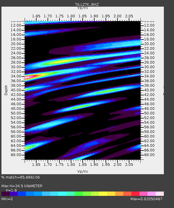
| Estimated Moho Depth: |
34.5 km |
| Estimated Crust Vp/Vs: |
1.60 |
| Assumed Crust Vp: |
6.566 km/s |
| Estimated Crust Vs: |
4.104 km/s |
| Estimated Crust Poisson's Ratio: |
0.18 |
|
| Radial Match: |
95.696106 % |
| Radial Bump: |
400 |
| Transverse Match: |
87.02717 % |
| Transverse Bump: |
400 |
| SOD ConfigId: |
13570011 |
| Insert Time: |
2019-04-29 02:39:52.937 +0000 |
| GWidth: |
2.5 |
| Max Bumps: |
400 |
| Tol: |
0.001 |
|

Signal To Noise
| Channel | StoN | STA | LTA |
| TA:L27K: :BHZ:20171104T09:12:07.324971Z | 44.49241 | 3.701749E-6 | 8.319956E-8 |
| TA:L27K: :BHN:20171104T09:12:07.324971Z | 15.150503 | 1.3944378E-6 | 9.2039045E-8 |
| TA:L27K: :BHE:20171104T09:12:07.324971Z | 13.766864 | 8.7834303E-7 | 6.3801245E-8 |
| Arrivals |
| Ps | 3.3 SECOND |
| PpPs | 13 SECOND |
| PsPs/PpSs | 16 SECOND |


