You are here: Home > Network List > TA - USArray Transportable Network (new EarthScope stations) Stations List
> Station MSTX Muleshoe, TX, USA > Earthquake Result Viewer
MSTX Muleshoe, TX, USA - Earthquake Result Viewer
| Earthquake location: |
Tonga Islands |
| Earthquake latitude/longitude: |
-15.4/-173.2 |
| Earthquake time(UTC): |
2017/11/04 (308) 09:00:19 GMT |
| Earthquake Depth: |
10 km |
| Earthquake Magnitude: |
6.8 Mww |
| Earthquake Catalog/Contributor: |
NEIC PDE/us |
|
| Network: |
TA USArray Transportable Network (new EarthScope stations) |
| Station: |
MSTX Muleshoe, TX, USA |
| Lat/Lon: |
33.97 N/102.77 W |
| Elevation: |
1167 m |
|
| Distance: |
83.0 deg |
| Az: |
52.095 deg |
| Baz: |
246.341 deg |
| Ray Param: |
0.046500504 |
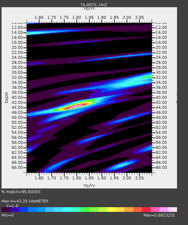
| Estimated Moho Depth: |
43.25 km |
| Estimated Crust Vp/Vs: |
1.80 |
| Assumed Crust Vp: |
6.129 km/s |
| Estimated Crust Vs: |
3.405 km/s |
| Estimated Crust Poisson's Ratio: |
0.28 |
|
| Radial Match: |
95.80083 % |
| Radial Bump: |
232 |
| Transverse Match: |
87.21075 % |
| Transverse Bump: |
335 |
| SOD ConfigId: |
13570011 |
| Insert Time: |
2019-04-29 02:40:09.444 +0000 |
| GWidth: |
2.5 |
| Max Bumps: |
400 |
| Tol: |
0.001 |
|

Signal To Noise
| Channel | StoN | STA | LTA |
| TA:MSTX: :HHZ:20171104T09:12:12.909993Z | 35.12258 | 4.5784004E-6 | 1.303549E-7 |
| TA:MSTX: :HHN:20171104T09:12:12.909993Z | 3.8269506 | 6.491034E-7 | 1.6961376E-7 |
| TA:MSTX: :HHE:20171104T09:12:12.909993Z | 8.70537 | 1.5405501E-6 | 1.7696549E-7 |
| Arrivals |
| Ps | 5.8 SECOND |
| PpPs | 19 SECOND |
| PsPs/PpSs | 25 SECOND |


