You are here: Home > Network List > TA - USArray Transportable Network (new EarthScope stations) Stations List
> Station Q19A Hogan Spring (BLM), Cisco, UT, USA > Earthquake Result Viewer
Q19A Hogan Spring (BLM), Cisco, UT, USA - Earthquake Result Viewer
| Earthquake location: |
Vanuatu Islands |
| Earthquake latitude/longitude: |
-13.5/167.0 |
| Earthquake time(UTC): |
2008/09/08 (252) 18:52:06 GMT |
| Earthquake Depth: |
110 km |
| Earthquake Magnitude: |
6.4 MB, 6.9 MW, 6.9 MW |
| Earthquake Catalog/Contributor: |
WHDF/NEIC |
|
| Network: |
TA USArray Transportable Network (new EarthScope stations) |
| Station: |
Q19A Hogan Spring (BLM), Cisco, UT, USA |
| Lat/Lon: |
38.96 N/109.26 W |
| Elevation: |
1283 m |
|
| Distance: |
93.6 deg |
| Az: |
50.953 deg |
| Baz: |
255.672 deg |
| Ray Param: |
0.041165084 |
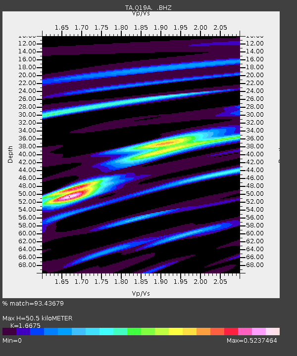
| Estimated Moho Depth: |
50.5 km |
| Estimated Crust Vp/Vs: |
1.67 |
| Assumed Crust Vp: |
6.291 km/s |
| Estimated Crust Vs: |
3.773 km/s |
| Estimated Crust Poisson's Ratio: |
0.22 |
|
| Radial Match: |
93.43679 % |
| Radial Bump: |
400 |
| Transverse Match: |
80.70146 % |
| Transverse Bump: |
400 |
| SOD ConfigId: |
2560 |
| Insert Time: |
2010-03-06 05:56:25.339 +0000 |
| GWidth: |
2.5 |
| Max Bumps: |
400 |
| Tol: |
0.001 |
|
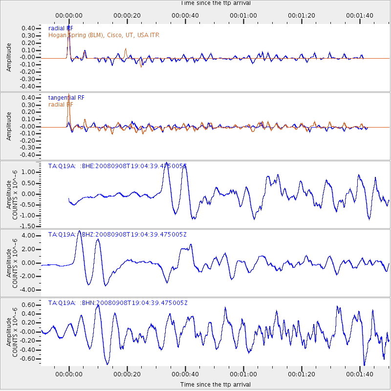
Signal To Noise
| Channel | StoN | STA | LTA |
| TA:Q19A: :BHZ:20080908T19:04:39.475005Z | 25.244864 | 2.633403E-6 | 1.0431441E-7 |
| TA:Q19A: :BHN:20080908T19:04:39.475005Z | 2.4865146 | 2.5822425E-7 | 1.03849885E-7 |
| TA:Q19A: :BHE:20080908T19:04:39.475005Z | 5.8888016 | 8.397242E-7 | 1.4259679E-7 |
| Arrivals |
| Ps | 5.5 SECOND |
| PpPs | 21 SECOND |
| PsPs/PpSs | 26 SECOND |


