You are here: Home > Network List > TA - USArray Transportable Network (new EarthScope stations) Stations List
> Station Q19A Hogan Spring (BLM), Cisco, UT, USA > Earthquake Result Viewer
Q19A Hogan Spring (BLM), Cisco, UT, USA - Earthquake Result Viewer
| Earthquake location: |
Andreanof Islands, Aleutian Is. |
| Earthquake latitude/longitude: |
51.4/-179.0 |
| Earthquake time(UTC): |
2007/12/21 (355) 07:24:34 GMT |
| Earthquake Depth: |
30 km |
| Earthquake Magnitude: |
6.1 MB, 6.2 MW, 6.3 ML |
| Earthquake Catalog/Contributor: |
WHDF/NEIC |
|
| Network: |
TA USArray Transportable Network (new EarthScope stations) |
| Station: |
Q19A Hogan Spring (BLM), Cisco, UT, USA |
| Lat/Lon: |
38.96 N/109.26 W |
| Elevation: |
1283 m |
|
| Distance: |
48.9 deg |
| Az: |
76.025 deg |
| Baz: |
308.707 deg |
| Ray Param: |
0.0689922 |
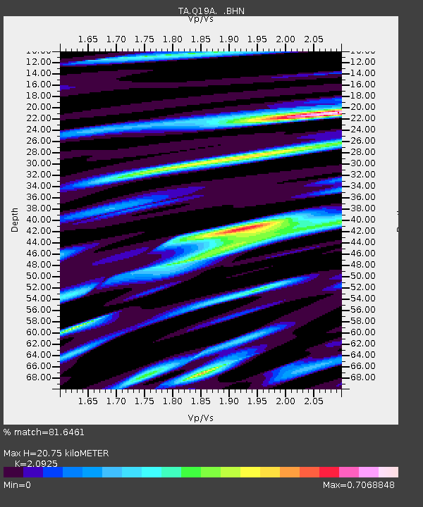
| Estimated Moho Depth: |
20.75 km |
| Estimated Crust Vp/Vs: |
2.09 |
| Assumed Crust Vp: |
6.291 km/s |
| Estimated Crust Vs: |
3.006 km/s |
| Estimated Crust Poisson's Ratio: |
0.35 |
|
| Radial Match: |
81.6461 % |
| Radial Bump: |
400 |
| Transverse Match: |
44.2401 % |
| Transverse Bump: |
400 |
| SOD ConfigId: |
2564 |
| Insert Time: |
2010-03-06 05:56:47.792 +0000 |
| GWidth: |
2.5 |
| Max Bumps: |
400 |
| Tol: |
0.001 |
|
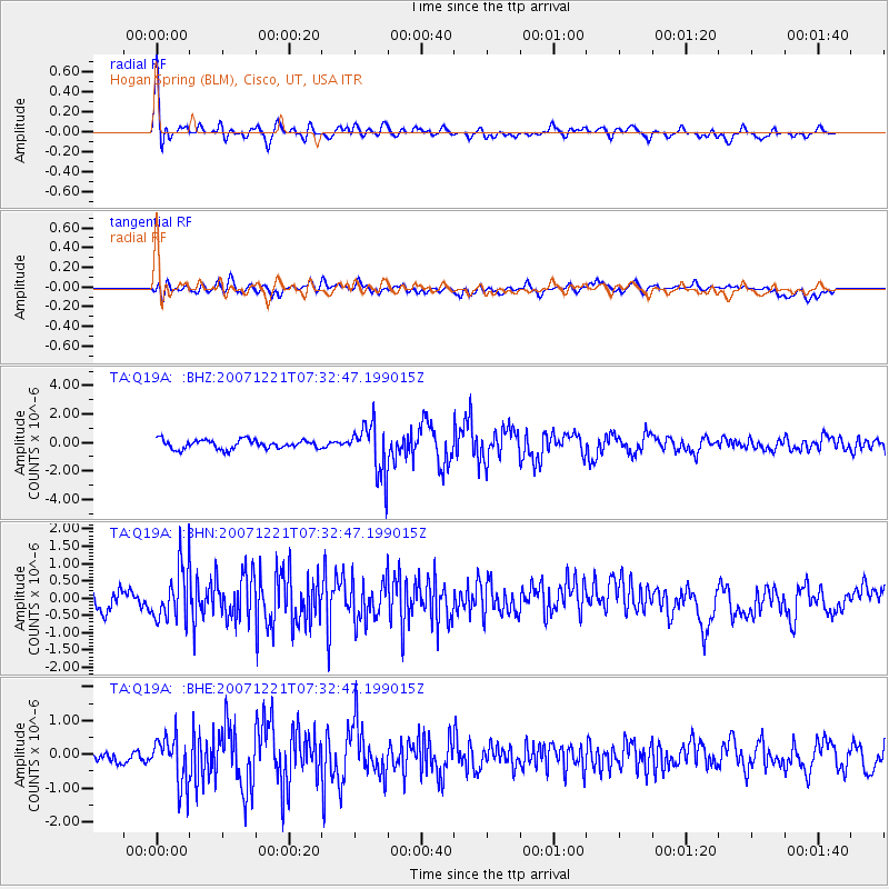
Signal To Noise
| Channel | StoN | STA | LTA |
| TA:Q19A: :BHN:20071221T07:32:47.199015Z | 2.73697 | 7.761869E-7 | 2.835935E-7 |
| TA:Q19A: :BHE:20071221T07:32:47.199015Z | 2.375644 | 7.2655183E-7 | 3.0583362E-7 |
| TA:Q19A: :BHZ:20071221T07:32:47.199015Z | 5.6486225 | 1.8012629E-6 | 3.1888536E-7 |
| Arrivals |
| Ps | 3.8 SECOND |
| PpPs | 9.7 SECOND |
| PsPs/PpSs | 14 SECOND |


