You are here: Home > Network List > UO - University of Oregon Regional Network Stations List
> Station JESE Wamic, OR, USA > Earthquake Result Viewer
JESE Wamic, OR, USA - Earthquake Result Viewer
| Earthquake location: |
Tonga Islands |
| Earthquake latitude/longitude: |
-15.4/-173.2 |
| Earthquake time(UTC): |
2017/11/04 (308) 09:00:19 GMT |
| Earthquake Depth: |
10 km |
| Earthquake Magnitude: |
6.8 Mww |
| Earthquake Catalog/Contributor: |
NEIC PDE/us |
|
| Network: |
UO University of Oregon Regional Network |
| Station: |
JESE Wamic, OR, USA |
| Lat/Lon: |
45.24 N/121.32 W |
| Elevation: |
592 m |
|
| Distance: |
76.5 deg |
| Az: |
34.883 deg |
| Baz: |
231.348 deg |
| Ray Param: |
0.050985638 |
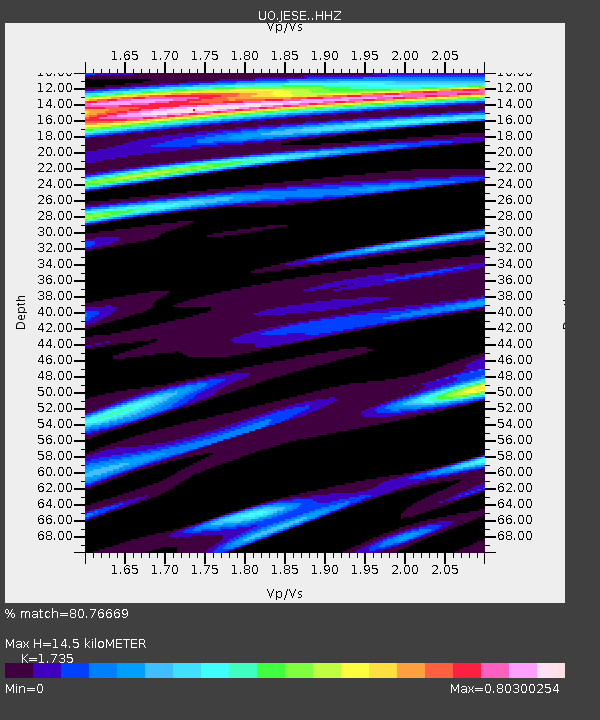
| Estimated Moho Depth: |
14.5 km |
| Estimated Crust Vp/Vs: |
1.74 |
| Assumed Crust Vp: |
6.597 km/s |
| Estimated Crust Vs: |
3.803 km/s |
| Estimated Crust Poisson's Ratio: |
0.25 |
|
| Radial Match: |
80.76669 % |
| Radial Bump: |
400 |
| Transverse Match: |
84.58608 % |
| Transverse Bump: |
400 |
| SOD ConfigId: |
13570011 |
| Insert Time: |
2019-04-29 02:41:37.992 +0000 |
| GWidth: |
2.5 |
| Max Bumps: |
400 |
| Tol: |
0.001 |
|

Signal To Noise
| Channel | StoN | STA | LTA |
| UO:JESE: :HHZ:20171104T09:11:37.518025Z | 17.053448 | 7.9660895E-6 | 4.671249E-7 |
| UO:JESE: :HHN:20171104T09:11:37.518025Z | 0.78171194 | 7.7511396E-7 | 9.915597E-7 |
| UO:JESE: :HHE:20171104T09:11:37.518025Z | 1.2101538 | 5.7348007E-7 | 4.738902E-7 |
| Arrivals |
| Ps | 1.7 SECOND |
| PpPs | 5.8 SECOND |
| PsPs/PpSs | 7.5 SECOND |


