You are here: Home > Network List > TA - USArray Transportable Network (new EarthScope stations) Stations List
> Station Q19A Hogan Spring (BLM), Cisco, UT, USA > Earthquake Result Viewer
Q19A Hogan Spring (BLM), Cisco, UT, USA - Earthquake Result Viewer
| Earthquake location: |
Peru-Ecuador Border Region |
| Earthquake latitude/longitude: |
-2.3/-77.8 |
| Earthquake time(UTC): |
2007/11/16 (320) 03:13:00 GMT |
| Earthquake Depth: |
123 km |
| Earthquake Magnitude: |
6.3 MB, 6.8 MW, 6.7 MW |
| Earthquake Catalog/Contributor: |
WHDF/NEIC |
|
| Network: |
TA USArray Transportable Network (new EarthScope stations) |
| Station: |
Q19A Hogan Spring (BLM), Cisco, UT, USA |
| Lat/Lon: |
38.96 N/109.26 W |
| Elevation: |
1283 m |
|
| Distance: |
50.2 deg |
| Az: |
328.069 deg |
| Baz: |
137.329 deg |
| Ray Param: |
0.0677716 |
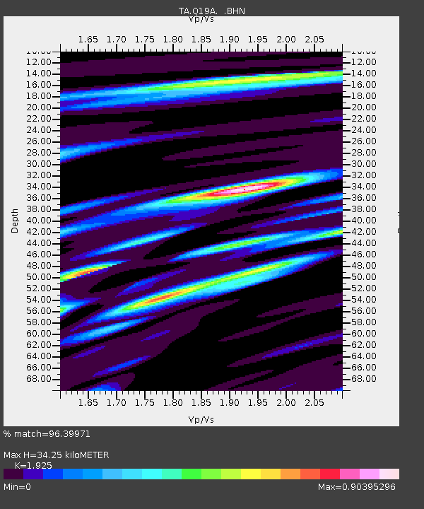
| Estimated Moho Depth: |
34.25 km |
| Estimated Crust Vp/Vs: |
1.92 |
| Assumed Crust Vp: |
6.291 km/s |
| Estimated Crust Vs: |
3.268 km/s |
| Estimated Crust Poisson's Ratio: |
0.32 |
|
| Radial Match: |
96.39971 % |
| Radial Bump: |
400 |
| Transverse Match: |
90.84772 % |
| Transverse Bump: |
400 |
| SOD ConfigId: |
2564 |
| Insert Time: |
2010-03-06 05:56:56.204 +0000 |
| GWidth: |
2.5 |
| Max Bumps: |
400 |
| Tol: |
0.001 |
|
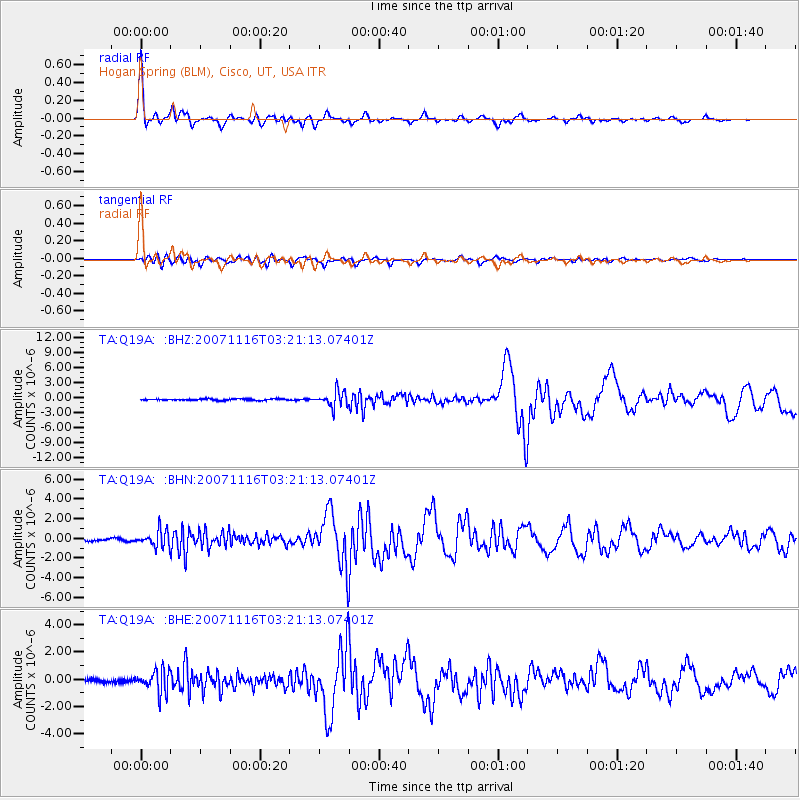
Signal To Noise
| Channel | StoN | STA | LTA |
| TA:Q19A: :BHN:20071116T03:21:13.07401Z | 5.578633 | 8.1932046E-7 | 1.468676E-7 |
| TA:Q19A: :BHE:20071116T03:21:13.07401Z | 5.322224 | 8.239654E-7 | 1.5481598E-7 |
| TA:Q19A: :BHZ:20071116T03:21:13.07401Z | 10.210669 | 1.5685807E-6 | 1.5362174E-7 |
| Arrivals |
| Ps | 5.3 SECOND |
| PpPs | 15 SECOND |
| PsPs/PpSs | 20 SECOND |


