You are here: Home > Network List > UW - Pacific Northwest Regional Seismic Network Stations List
> Station GNW Green Mountain (BB) > Earthquake Result Viewer
GNW Green Mountain (BB) - Earthquake Result Viewer
| Earthquake location: |
Tonga Islands |
| Earthquake latitude/longitude: |
-15.4/-173.2 |
| Earthquake time(UTC): |
2017/11/04 (308) 09:00:19 GMT |
| Earthquake Depth: |
10 km |
| Earthquake Magnitude: |
6.8 Mww |
| Earthquake Catalog/Contributor: |
NEIC PDE/us |
|
| Network: |
UW Pacific Northwest Regional Seismic Network |
| Station: |
GNW Green Mountain (BB) |
| Lat/Lon: |
47.56 N/122.83 W |
| Elevation: |
160 m |
|
| Distance: |
77.1 deg |
| Az: |
32.359 deg |
| Baz: |
229.682 deg |
| Ray Param: |
0.050535675 |
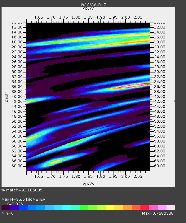
| Estimated Moho Depth: |
35.5 km |
| Estimated Crust Vp/Vs: |
2.03 |
| Assumed Crust Vp: |
6.566 km/s |
| Estimated Crust Vs: |
3.243 km/s |
| Estimated Crust Poisson's Ratio: |
0.34 |
|
| Radial Match: |
93.105835 % |
| Radial Bump: |
327 |
| Transverse Match: |
89.61481 % |
| Transverse Bump: |
400 |
| SOD ConfigId: |
13570011 |
| Insert Time: |
2019-04-29 02:42:00.661 +0000 |
| GWidth: |
2.5 |
| Max Bumps: |
400 |
| Tol: |
0.001 |
|
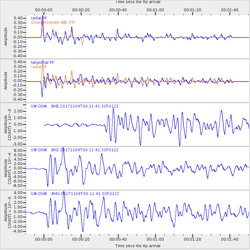
Signal To Noise
| Channel | StoN | STA | LTA |
| UW:GNW: :BHZ:20171104T09:11:41.305012Z | 38.152596 | 4.0029327E-6 | 1.0491901E-7 |
| UW:GNW: :BHN:20171104T09:11:41.305012Z | 9.738721 | 1.5753986E-6 | 1.6176648E-7 |
| UW:GNW: :BHE:20171104T09:11:41.305012Z | 5.508023 | 7.117563E-7 | 1.2922173E-7 |
| Arrivals |
| Ps | 5.7 SECOND |
| PpPs | 16 SECOND |
| PsPs/PpSs | 22 SECOND |


