You are here: Home > Network List > TA - USArray Transportable Network (new EarthScope stations) Stations List
> Station Q19A Hogan Spring (BLM), Cisco, UT, USA > Earthquake Result Viewer
Q19A Hogan Spring (BLM), Cisco, UT, USA - Earthquake Result Viewer
| Earthquake location: |
Kuril Islands |
| Earthquake latitude/longitude: |
45.8/150.1 |
| Earthquake time(UTC): |
2007/09/03 (246) 16:14:53 GMT |
| Earthquake Depth: |
94 km |
| Earthquake Magnitude: |
6.3 MB, 6.2 MW, 6.2 ME |
| Earthquake Catalog/Contributor: |
WHDF/NEIC |
|
| Network: |
TA USArray Transportable Network (new EarthScope stations) |
| Station: |
Q19A Hogan Spring (BLM), Cisco, UT, USA |
| Lat/Lon: |
38.96 N/109.26 W |
| Elevation: |
1283 m |
|
| Distance: |
69.7 deg |
| Az: |
54.772 deg |
| Baz: |
312.908 deg |
| Ray Param: |
0.05522992 |
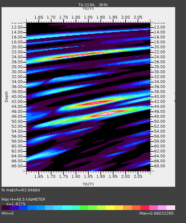
| Estimated Moho Depth: |
46.5 km |
| Estimated Crust Vp/Vs: |
1.93 |
| Assumed Crust Vp: |
6.291 km/s |
| Estimated Crust Vs: |
3.264 km/s |
| Estimated Crust Poisson's Ratio: |
0.32 |
|
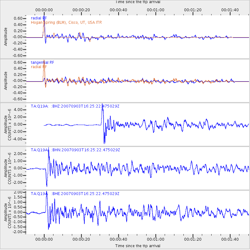
| Radial Match: |
93.84664 % |
| Radial Bump: |
376 |
| Transverse Match: |
78.91489 % |
| Transverse Bump: |
400 |
| SOD ConfigId: |
2564 |
| Insert Time: |
2010-03-06 05:57:08.237 +0000 |
| GWidth: |
2.5 |
| Max Bumps: |
400 |
| Tol: |
0.001 |
|
Signal To Noise
| Channel | StoN | STA | LTA |
| TA:Q19A: :BHN:20070903T16:25:22.475029Z | 17.889967 | 1.0786811E-6 | 6.029531E-8 |
| TA:Q19A: :BHE:20070903T16:25:22.475029Z | 13.024387 | 8.942258E-7 | 6.8657805E-8 |
| TA:Q19A: :BHZ:20070903T16:25:22.475029Z | 24.777805 | 2.4662488E-6 | 9.9534596E-8 |
| Arrivals |
| Ps | 7.1 SECOND |
| PpPs | 21 SECOND |
| PsPs/PpSs | 28 SECOND |


