You are here: Home > Network List > XV14 - Fault Locations and Alaska Tectonics from Seismicity Stations List
> Station F6TP Tanana River 6, Topo, AK, USA > Earthquake Result Viewer
F6TP Tanana River 6, Topo, AK, USA - Earthquake Result Viewer
| Earthquake location: |
Tonga Islands |
| Earthquake latitude/longitude: |
-15.4/-173.2 |
| Earthquake time(UTC): |
2017/11/04 (308) 09:00:19 GMT |
| Earthquake Depth: |
10 km |
| Earthquake Magnitude: |
6.8 Mww |
| Earthquake Catalog/Contributor: |
NEIC PDE/us |
|
| Network: |
XV Fault Locations and Alaska Tectonics from Seismicity |
| Station: |
F6TP Tanana River 6, Topo, AK, USA |
| Lat/Lon: |
64.87 N/149.56 W |
| Elevation: |
120 m |
|
| Distance: |
82.0 deg |
| Az: |
9.965 deg |
| Baz: |
203.015 deg |
| Ray Param: |
0.047199056 |
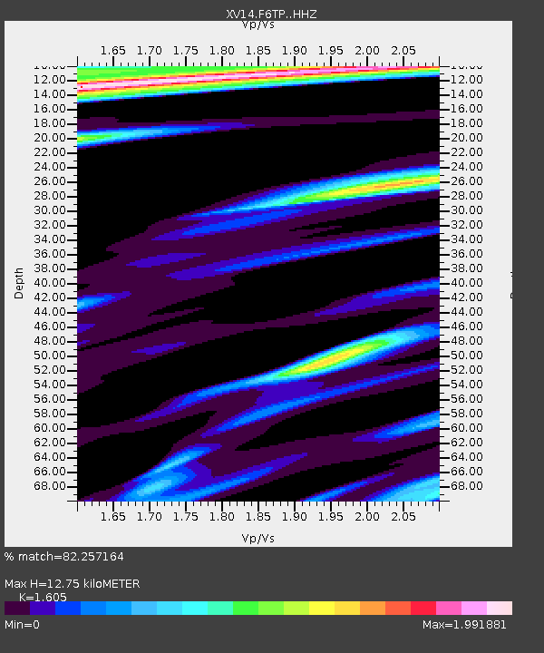
| Estimated Moho Depth: |
12.75 km |
| Estimated Crust Vp/Vs: |
1.61 |
| Assumed Crust Vp: |
6.566 km/s |
| Estimated Crust Vs: |
4.091 km/s |
| Estimated Crust Poisson's Ratio: |
0.18 |
|
| Radial Match: |
82.257164 % |
| Radial Bump: |
400 |
| Transverse Match: |
87.58218 % |
| Transverse Bump: |
374 |
| SOD ConfigId: |
13570011 |
| Insert Time: |
2019-04-29 02:42:35.114 +0000 |
| GWidth: |
2.5 |
| Max Bumps: |
400 |
| Tol: |
0.001 |
|

Signal To Noise
| Channel | StoN | STA | LTA |
| XV:F6TP: :HHZ:20171104T09:12:07.769978Z | 44.84461 | 6.1495775E-6 | 1.371308E-7 |
| XV:F6TP: :HHN:20171104T09:12:07.769978Z | 8.497501 | 3.9102397E-6 | 4.6016348E-7 |
| XV:F6TP: :HHE:20171104T09:12:07.769978Z | 7.827582 | 2.6875073E-6 | 3.4333812E-7 |
| Arrivals |
| Ps | 1.2 SECOND |
| PpPs | 4.9 SECOND |
| PsPs/PpSs | 6.1 SECOND |


