You are here: Home > Network List > TA - USArray Transportable Network (new EarthScope stations) Stations List
> Station Q19A Hogan Spring (BLM), Cisco, UT, USA > Earthquake Result Viewer
Q19A Hogan Spring (BLM), Cisco, UT, USA - Earthquake Result Viewer
| Earthquake location: |
Jujuy Province, Argentina |
| Earthquake latitude/longitude: |
-22.2/-65.8 |
| Earthquake time(UTC): |
2007/07/21 (202) 15:34:52 GMT |
| Earthquake Depth: |
290 km |
| Earthquake Magnitude: |
5.8 MB, 6.4 MW, 6.3 MW |
| Earthquake Catalog/Contributor: |
WHDF/NEIC |
|
| Network: |
TA USArray Transportable Network (new EarthScope stations) |
| Station: |
Q19A Hogan Spring (BLM), Cisco, UT, USA |
| Lat/Lon: |
38.96 N/109.26 W |
| Elevation: |
1283 m |
|
| Distance: |
73.2 deg |
| Az: |
325.902 deg |
| Baz: |
138.197 deg |
| Ray Param: |
0.05236264 |
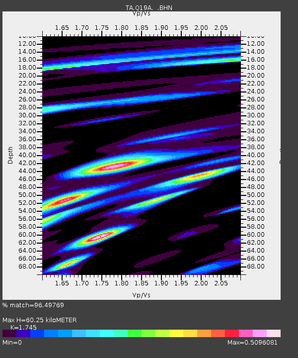
| Estimated Moho Depth: |
60.25 km |
| Estimated Crust Vp/Vs: |
1.75 |
| Assumed Crust Vp: |
6.291 km/s |
| Estimated Crust Vs: |
3.605 km/s |
| Estimated Crust Poisson's Ratio: |
0.26 |
|
| Radial Match: |
96.49769 % |
| Radial Bump: |
388 |
| Transverse Match: |
74.46262 % |
| Transverse Bump: |
400 |
| SOD ConfigId: |
2564 |
| Insert Time: |
2010-03-06 05:57:20.887 +0000 |
| GWidth: |
2.5 |
| Max Bumps: |
400 |
| Tol: |
0.001 |
|
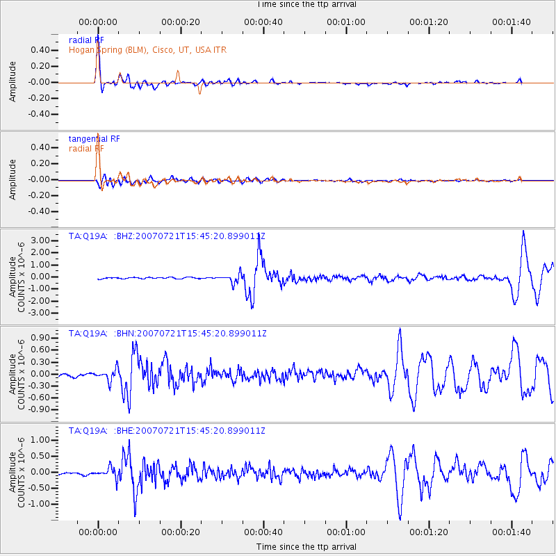
Signal To Noise
| Channel | StoN | STA | LTA |
| TA:Q19A: :BHN:20070721T15:45:20.899011Z | 2.742217 | 1.5049778E-7 | 5.488179E-8 |
| TA:Q19A: :BHE:20070721T15:45:20.899011Z | 4.607881 | 1.626676E-7 | 3.530204E-8 |
| TA:Q19A: :BHZ:20070721T15:45:20.899011Z | 6.926366 | 3.7529298E-7 | 5.4183243E-8 |
| Arrivals |
| Ps | 7.4 SECOND |
| PpPs | 25 SECOND |
| PsPs/PpSs | 33 SECOND |


