You are here: Home > Network List > ZP16 - Seismic Investigation of South Central Oklahoma Stations List
> Station SC09 Katie, Oklahoma, USA > Earthquake Result Viewer
SC09 Katie, Oklahoma, USA - Earthquake Result Viewer
| Earthquake location: |
Tonga Islands |
| Earthquake latitude/longitude: |
-15.4/-173.2 |
| Earthquake time(UTC): |
2017/11/04 (308) 09:00:19 GMT |
| Earthquake Depth: |
10 km |
| Earthquake Magnitude: |
6.8 Mww |
| Earthquake Catalog/Contributor: |
NEIC PDE/us |
|
| Network: |
ZP Seismic Investigation of South Central Oklahoma |
| Station: |
SC09 Katie, Oklahoma, USA |
| Lat/Lon: |
34.55 N/97.37 W |
| Elevation: |
291 m |
|
| Distance: |
87.4 deg |
| Az: |
53.252 deg |
| Baz: |
249.469 deg |
| Ray Param: |
0.043379504 |
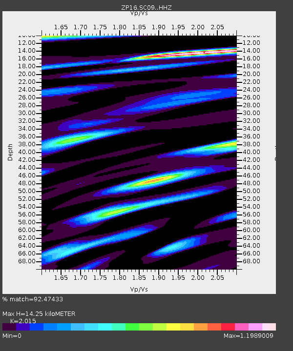
| Estimated Moho Depth: |
14.25 km |
| Estimated Crust Vp/Vs: |
2.02 |
| Assumed Crust Vp: |
6.426 km/s |
| Estimated Crust Vs: |
3.189 km/s |
| Estimated Crust Poisson's Ratio: |
0.34 |
|
| Radial Match: |
92.47433 % |
| Radial Bump: |
400 |
| Transverse Match: |
92.47435 % |
| Transverse Bump: |
400 |
| SOD ConfigId: |
13570011 |
| Insert Time: |
2019-04-29 02:43:38.246 +0000 |
| GWidth: |
2.5 |
| Max Bumps: |
400 |
| Tol: |
0.001 |
|

Signal To Noise
| Channel | StoN | STA | LTA |
| ZP:SC09: :HHZ:20171104T09:12:34.698994Z | 9.932235 | 2.573237E-6 | 2.5907937E-7 |
| $trig.getChannelId() | $trig.getValue() | $trig.getSTA() | $trig.getLTA() |
| ZP:SC09: :HH2:20171104T09:12:34.698994Z | 2.107856 | 6.548329E-7 | 3.10663E-7 |
| Arrivals |
| Ps | 2.3 SECOND |
| PpPs | 6.6 SECOND |
| PsPs/PpSs | 8.9 SECOND |


