You are here: Home > Network List > TA - USArray Transportable Network (new EarthScope stations) Stations List
> Station A21K Barrow, AK, USA > Earthquake Result Viewer
A21K Barrow, AK, USA - Earthquake Result Viewer

| Earthquake location: |
Loyalty Islands |
| Earthquake latitude/longitude: |
-21.8/169.0 |
| Earthquake time(UTC): |
2017/11/04 (308) 09:27:42 GMT |
| Earthquake Depth: |
9.5 km |
| Earthquake Magnitude: |
5.5 mb |
| Earthquake Catalog/Contributor: |
NEIC PDE/us |
|
| Network: |
TA USArray Transportable Network (new EarthScope stations) |
| Station: |
A21K Barrow, AK, USA |
| Lat/Lon: |
71.32 N/156.62 W |
| Elevation: |
577 m |
|
| Distance: |
95.9 deg |
| Az: |
10.546 deg |
| Baz: |
211.872 deg |
| Ray Param: |
0.040670484 |
| Estimated Moho Depth: |
12.25 km |
| Estimated Crust Vp/Vs: |
1.60 |
| Assumed Crust Vp: |
6.048 km/s |
| Estimated Crust Vs: |
3.78 km/s |
| Estimated Crust Poisson's Ratio: |
0.18 |
|
| Radial Match: |
91.85671 % |
| Radial Bump: |
400 |
| Transverse Match: |
74.76948 % |
| Transverse Bump: |
400 |
| SOD ConfigId: |
13570011 |
| Insert Time: |
2019-04-29 02:46:39.063 +0000 |
| GWidth: |
2.5 |
| Max Bumps: |
400 |
| Tol: |
0.001 |
|
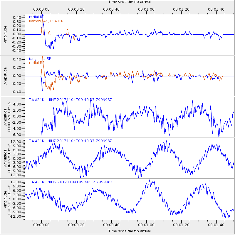
Signal To Noise
| Channel | StoN | STA | LTA |
| TA:A21K: :BHZ:20171104T09:40:37.799998Z | 1.5241272 | 5.5957603E-6 | 3.671452E-6 |
| TA:A21K: :BHN:20171104T09:40:37.799998Z | 2.071734 | 5.7895018E-6 | 2.7945198E-6 |
| TA:A21K: :BHE:20171104T09:40:37.799998Z | 1.003847 | 2.537975E-6 | 2.5282488E-6 |
| Arrivals |
| Ps | 1.2 SECOND |
| PpPs | 5.2 SECOND |
| PsPs/PpSs | 6.4 SECOND |


