You are here: Home > Network List > TA - USArray Transportable Network (new EarthScope stations) Stations List
> Station D25K Kavik River, AK, USA > Earthquake Result Viewer
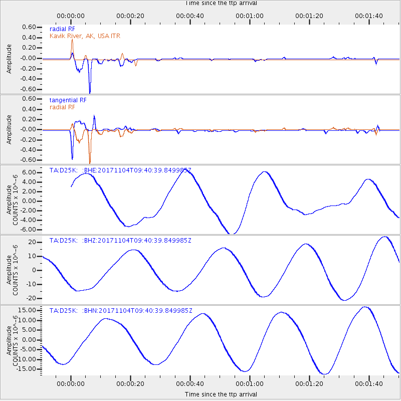
D25K Kavik River, AK, USA - Earthquake Result Viewer
*The percent match for this event was below the threshold and hence no stack was calculated.
| Earthquake location: |
Loyalty Islands |
| Earthquake latitude/longitude: |
-21.8/169.0 |
| Earthquake time(UTC): |
2017/11/04 (308) 09:27:42 GMT |
| Earthquake Depth: |
9.5 km |
| Earthquake Magnitude: |
5.5 mb |
| Earthquake Catalog/Contributor: |
NEIC PDE/us |
|
| Network: |
TA USArray Transportable Network (new EarthScope stations) |
| Station: |
D25K Kavik River, AK, USA |
| Lat/Lon: |
69.32 N/146.38 W |
| Elevation: |
770 m |
|
| Distance: |
96.3 deg |
| Az: |
14.546 deg |
| Baz: |
221.089 deg |
| Ray Param: |
$rayparam |
*The percent match for this event was below the threshold and hence was not used in the summary stack. |
|
| Radial Match: |
93.2402 % |
| Radial Bump: |
213 |
| Transverse Match: |
75.06863 % |
| Transverse Bump: |
400 |
| SOD ConfigId: |
13570011 |
| Insert Time: |
2019-04-29 02:46:42.217 +0000 |
| GWidth: |
2.5 |
| Max Bumps: |
400 |
| Tol: |
0.001 |
|
Signal To Noise
| Channel | StoN | STA | LTA |
| TA:D25K: :BHZ:20171104T09:40:39.849985Z | 1.753651 | 1.52417315E-5 | 8.691428E-6 |
| TA:D25K: :BHN:20171104T09:40:39.849985Z | 1.7045602 | 8.079099E-6 | 4.739697E-6 |
| TA:D25K: :BHE:20171104T09:40:39.849985Z | 0.45096722 | 1.9377203E-6 | 4.29681E-6 |
| Arrivals |
| Ps | |
| PpPs | |
| PsPs/PpSs | |


