You are here: Home > Network List > TA - USArray Transportable Network (new EarthScope stations) Stations List
> Station E27K Coleen River, AK, USA > Earthquake Result Viewer
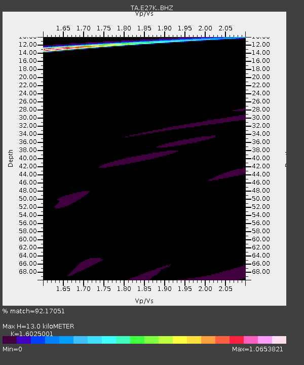
E27K Coleen River, AK, USA - Earthquake Result Viewer
| Earthquake location: |
Loyalty Islands |
| Earthquake latitude/longitude: |
-21.8/169.0 |
| Earthquake time(UTC): |
2017/11/04 (308) 09:27:42 GMT |
| Earthquake Depth: |
9.5 km |
| Earthquake Magnitude: |
5.5 mb |
| Earthquake Catalog/Contributor: |
NEIC PDE/us |
|
| Network: |
TA USArray Transportable Network (new EarthScope stations) |
| Station: |
E27K Coleen River, AK, USA |
| Lat/Lon: |
68.19 N/141.60 W |
| Elevation: |
654 m |
|
| Distance: |
96.7 deg |
| Az: |
16.609 deg |
| Baz: |
225.307 deg |
| Ray Param: |
0.040445752 |
| Estimated Moho Depth: |
13.0 km |
| Estimated Crust Vp/Vs: |
1.60 |
| Assumed Crust Vp: |
6.522 km/s |
| Estimated Crust Vs: |
4.07 km/s |
| Estimated Crust Poisson's Ratio: |
0.18 |
|
| Radial Match: |
92.17051 % |
| Radial Bump: |
400 |
| Transverse Match: |
85.67758 % |
| Transverse Bump: |
344 |
| SOD ConfigId: |
13570011 |
| Insert Time: |
2019-04-29 02:46:45.854 +0000 |
| GWidth: |
2.5 |
| Max Bumps: |
400 |
| Tol: |
0.001 |
|

Signal To Noise
| Channel | StoN | STA | LTA |
| TA:E27K: :BHZ:20171104T09:40:41.474985Z | 0.83744705 | 6.476053E-6 | 7.73309E-6 |
| TA:E27K: :BHN:20171104T09:40:41.474985Z | 1.4605331 | 1.1218483E-5 | 7.6810875E-6 |
| TA:E27K: :BHE:20171104T09:40:41.474985Z | 1.407243 | 6.1733504E-6 | 4.3868404E-6 |
| Arrivals |
| Ps | 1.2 SECOND |
| PpPs | 5.1 SECOND |
| PsPs/PpSs | 6.3 SECOND |


