You are here: Home > Network List > TA - USArray Transportable Network (new EarthScope stations) Stations List
> Station F26K Sheenjek River, AK, USA > Earthquake Result Viewer
F26K Sheenjek River, AK, USA - Earthquake Result Viewer
| Earthquake location: |
Loyalty Islands |
| Earthquake latitude/longitude: |
-21.8/169.0 |
| Earthquake time(UTC): |
2017/11/04 (308) 09:27:42 GMT |
| Earthquake Depth: |
9.5 km |
| Earthquake Magnitude: |
5.5 mb |
| Earthquake Catalog/Contributor: |
NEIC PDE/us |
|
| Network: |
TA USArray Transportable Network (new EarthScope stations) |
| Station: |
F26K Sheenjek River, AK, USA |
| Lat/Lon: |
67.69 N/144.15 W |
| Elevation: |
683 m |
|
| Distance: |
95.6 deg |
| Az: |
16.26 deg |
| Baz: |
222.983 deg |
| Ray Param: |
0.040727332 |
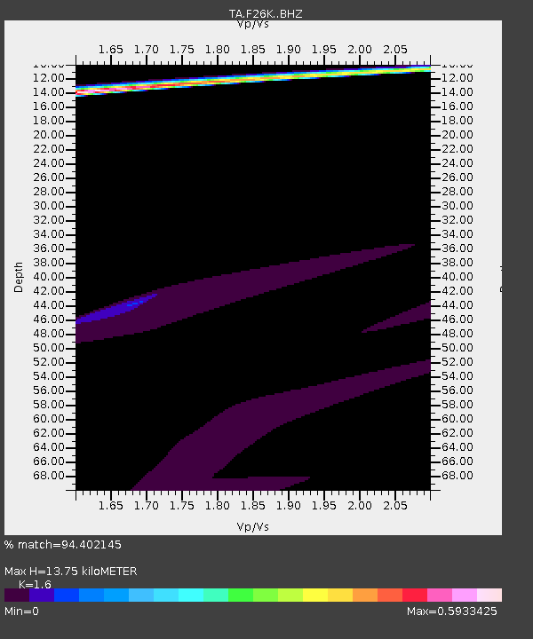
| Estimated Moho Depth: |
13.75 km |
| Estimated Crust Vp/Vs: |
1.60 |
| Assumed Crust Vp: |
6.522 km/s |
| Estimated Crust Vs: |
4.076 km/s |
| Estimated Crust Poisson's Ratio: |
0.18 |
|
| Radial Match: |
94.402145 % |
| Radial Bump: |
304 |
| Transverse Match: |
86.89344 % |
| Transverse Bump: |
284 |
| SOD ConfigId: |
13570011 |
| Insert Time: |
2019-04-29 02:46:47.592 +0000 |
| GWidth: |
2.5 |
| Max Bumps: |
400 |
| Tol: |
0.001 |
|
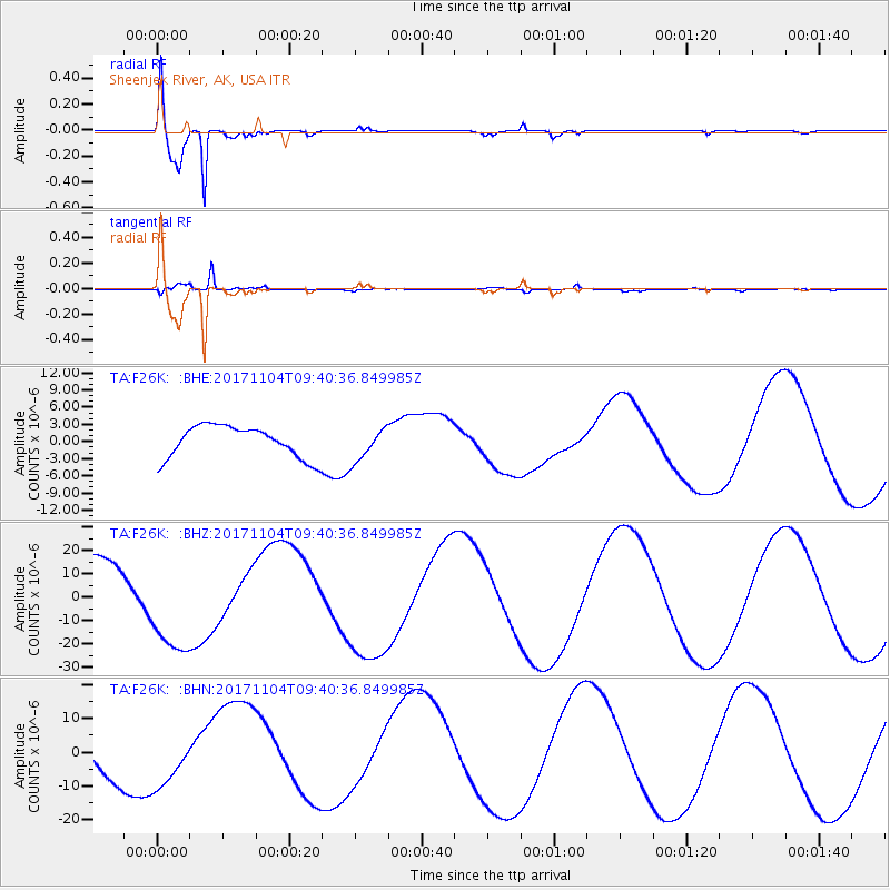
Signal To Noise
| Channel | StoN | STA | LTA |
| TA:F26K: :BHZ:20171104T09:40:36.849985Z | 1.7125541 | 2.0997019E-5 | 1.2260645E-5 |
| TA:F26K: :BHN:20171104T09:40:36.849985Z | 1.2047939 | 8.469157E-6 | 7.0295487E-6 |
| TA:F26K: :BHE:20171104T09:40:36.849985Z | 1.2377777 | 3.3373003E-6 | 2.6962032E-6 |
| Arrivals |
| Ps | 1.3 SECOND |
| PpPs | 5.4 SECOND |
| PsPs/PpSs | 6.7 SECOND |


