You are here: Home > Network List > TA - USArray Transportable Network (new EarthScope stations) Stations List
> Station H31M Peel River, Yukon, CAN > Earthquake Result Viewer
H31M Peel River, Yukon, CAN - Earthquake Result Viewer

| Earthquake location: |
Loyalty Islands |
| Earthquake latitude/longitude: |
-21.8/169.0 |
| Earthquake time(UTC): |
2017/11/04 (308) 09:27:42 GMT |
| Earthquake Depth: |
9.5 km |
| Earthquake Magnitude: |
5.5 mb |
| Earthquake Catalog/Contributor: |
NEIC PDE/us |
|
| Network: |
TA USArray Transportable Network (new EarthScope stations) |
| Station: |
H31M Peel River, Yukon, CAN |
| Lat/Lon: |
65.81 N/134.34 W |
| Elevation: |
642 m |
|
| Distance: |
97.2 deg |
| Az: |
20.313 deg |
| Baz: |
231.531 deg |
| Ray Param: |
0.040280834 |
| Estimated Moho Depth: |
12.5 km |
| Estimated Crust Vp/Vs: |
1.60 |
| Assumed Crust Vp: |
6.419 km/s |
| Estimated Crust Vs: |
4.012 km/s |
| Estimated Crust Poisson's Ratio: |
0.18 |
|
| Radial Match: |
94.37226 % |
| Radial Bump: |
400 |
| Transverse Match: |
78.894745 % |
| Transverse Bump: |
400 |
| SOD ConfigId: |
13570011 |
| Insert Time: |
2019-04-29 02:46:53.003 +0000 |
| GWidth: |
2.5 |
| Max Bumps: |
400 |
| Tol: |
0.001 |
|
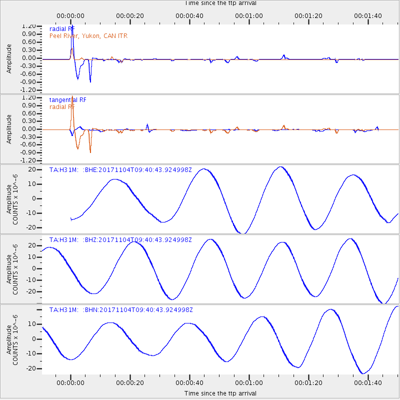
Signal To Noise
| Channel | StoN | STA | LTA |
| TA:H31M: :BHZ:20171104T09:40:43.924998Z | 0.913471 | 1.0677213E-5 | 1.1688618E-5 |
| TA:H31M: :BHN:20171104T09:40:43.924998Z | 1.6813276 | 1.25979595E-5 | 7.492865E-6 |
| TA:H31M: :BHE:20171104T09:40:43.924998Z | 1.768344 | 1.6627744E-5 | 9.403003E-6 |
| Arrivals |
| Ps | 1.2 SECOND |
| PpPs | 5.0 SECOND |
| PsPs/PpSs | 6.1 SECOND |


