You are here: Home > Network List > TA - USArray Transportable Network (new EarthScope stations) Stations List
> Station Q19A Hogan Spring (BLM), Cisco, UT, USA > Earthquake Result Viewer
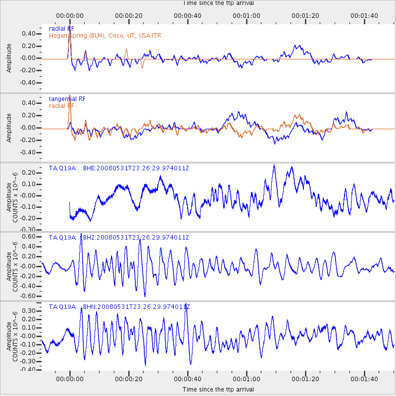
Q19A Hogan Spring (BLM), Cisco, UT, USA - Earthquake Result Viewer
*The percent match for this event was below the threshold and hence no stack was calculated.
| Earthquake location: |
Easter Island Region |
| Earthquake latitude/longitude: |
-28.9/-112.3 |
| Earthquake time(UTC): |
2008/05/31 (152) 23:16:04 GMT |
| Earthquake Depth: |
10 km |
| Earthquake Magnitude: |
5.5 MS, 5.4 MB, 5.8 MW, 5.8 MW |
| Earthquake Catalog/Contributor: |
WHDF/NEIC |
|
| Network: |
TA USArray Transportable Network (new EarthScope stations) |
| Station: |
Q19A Hogan Spring (BLM), Cisco, UT, USA |
| Lat/Lon: |
38.96 N/109.26 W |
| Elevation: |
1283 m |
|
| Distance: |
67.6 deg |
| Az: |
2.526 deg |
| Baz: |
182.84 deg |
| Ray Param: |
$rayparam |
*The percent match for this event was below the threshold and hence was not used in the summary stack. |
|
| Radial Match: |
71.47496 % |
| Radial Bump: |
400 |
| Transverse Match: |
25.8622 % |
| Transverse Bump: |
400 |
| SOD ConfigId: |
2504 |
| Insert Time: |
2010-03-06 05:58:52.078 +0000 |
| GWidth: |
2.5 |
| Max Bumps: |
400 |
| Tol: |
0.001 |
|
Signal To Noise
| Channel | StoN | STA | LTA |
| TA:Q19A: :BHZ:20080531T23:26:29.974011Z | 4.274294 | 2.7478947E-7 | 6.428886E-8 |
| TA:Q19A: :BHN:20080531T23:26:29.974011Z | 2.2169468 | 1.4478606E-7 | 6.530876E-8 |
| TA:Q19A: :BHE:20080531T23:26:29.974011Z | 1.662037 | 1.5261676E-7 | 9.1825136E-8 |
| Arrivals |
| Ps | |
| PpPs | |
| PsPs/PpSs | |


