You are here: Home > Network List > TA - USArray Transportable Network (new EarthScope stations) Stations List
> Station Q19A Hogan Spring (BLM), Cisco, UT, USA > Earthquake Result Viewer
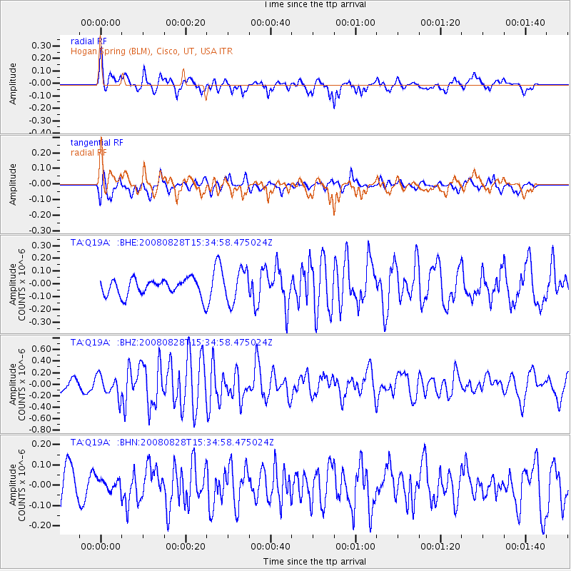
Q19A Hogan Spring (BLM), Cisco, UT, USA - Earthquake Result Viewer
*The percent match for this event was below the threshold and hence no stack was calculated.
| Earthquake location: |
North Of Ascension Island |
| Earthquake latitude/longitude: |
-0.2/-17.4 |
| Earthquake time(UTC): |
2008/08/28 (241) 15:22:23 GMT |
| Earthquake Depth: |
15 km |
| Earthquake Magnitude: |
5.8 MB, 5.9 MS, 6.3 MW, 6.3 MW |
| Earthquake Catalog/Contributor: |
WHDF/NEIC |
|
| Network: |
TA USArray Transportable Network (new EarthScope stations) |
| Station: |
Q19A Hogan Spring (BLM), Cisco, UT, USA |
| Lat/Lon: |
38.96 N/109.26 W |
| Elevation: |
1283 m |
|
| Distance: |
91.6 deg |
| Az: |
308.778 deg |
| Baz: |
88.998 deg |
| Ray Param: |
$rayparam |
*The percent match for this event was below the threshold and hence was not used in the summary stack. |
|
| Radial Match: |
69.15708 % |
| Radial Bump: |
400 |
| Transverse Match: |
60.4196 % |
| Transverse Bump: |
400 |
| SOD ConfigId: |
2504 |
| Insert Time: |
2010-03-06 05:59:04.454 +0000 |
| GWidth: |
2.5 |
| Max Bumps: |
400 |
| Tol: |
0.001 |
|
Signal To Noise
| Channel | StoN | STA | LTA |
| TA:Q19A: :BHZ:20080828T15:34:58.475024Z | 2.6062355 | 1.8900073E-7 | 7.2518674E-8 |
| TA:Q19A: :BHN:20080828T15:34:58.475024Z | 0.40288258 | 2.7084395E-8 | 6.722652E-8 |
| TA:Q19A: :BHE:20080828T15:34:58.475024Z | 1.9083503 | 1.2606176E-7 | 6.605798E-8 |
| Arrivals |
| Ps | |
| PpPs | |
| PsPs/PpSs | |


