You are here: Home > Network List > AT - Alaska Tsunami Warning Seismic System Stations List
> Station OHAK Old Harbor, Alaska > Earthquake Result Viewer
OHAK Old Harbor, Alaska - Earthquake Result Viewer
| Earthquake location: |
Tonga Islands |
| Earthquake latitude/longitude: |
-15.2/-173.3 |
| Earthquake time(UTC): |
2017/11/04 (308) 15:24:31 GMT |
| Earthquake Depth: |
10 km |
| Earthquake Magnitude: |
5.6 mb |
| Earthquake Catalog/Contributor: |
NEIC PDE/us |
|
| Network: |
AT Alaska Tsunami Warning Seismic System |
| Station: |
OHAK Old Harbor, Alaska |
| Lat/Lon: |
57.22 N/153.29 W |
| Elevation: |
78 m |
|
| Distance: |
74.0 deg |
| Az: |
11.183 deg |
| Baz: |
200.136 deg |
| Ray Param: |
0.052602235 |
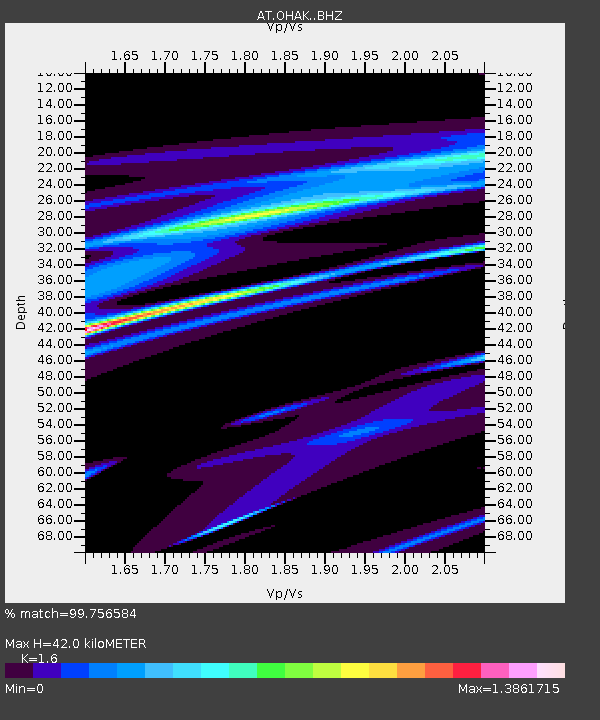
| Estimated Moho Depth: |
42.0 km |
| Estimated Crust Vp/Vs: |
1.60 |
| Assumed Crust Vp: |
6.134 km/s |
| Estimated Crust Vs: |
3.834 km/s |
| Estimated Crust Poisson's Ratio: |
0.18 |
|
| Radial Match: |
99.756584 % |
| Radial Bump: |
32 |
| Transverse Match: |
99.76361 % |
| Transverse Bump: |
37 |
| SOD ConfigId: |
13570011 |
| Insert Time: |
2019-04-29 02:58:30.814 +0000 |
| GWidth: |
2.5 |
| Max Bumps: |
400 |
| Tol: |
0.001 |
|

Signal To Noise
| Channel | StoN | STA | LTA |
| AT:OHAK: :BHZ:20171104T15:35:36.580012Z | 3.8002784 | 5.1662006E-8 | 1.359427E-8 |
| AT:OHAK: :BHN:20171104T15:35:36.580012Z | 3.8814073 | 2.819028E-6 | 7.262902E-7 |
| AT:OHAK: :BHE:20171104T15:35:36.580012Z | 0.7301709 | 2.7717006E-8 | 3.7959612E-8 |
| Arrivals |
| Ps | 4.2 SECOND |
| PpPs | 17 SECOND |
| PsPs/PpSs | 21 SECOND |


