You are here: Home > Network List > TA - USArray Transportable Network (new EarthScope stations) Stations List
> Station Q18A Rafter H Ranch, Green River, UT, USA > Earthquake Result Viewer
Q18A Rafter H Ranch, Green River, UT, USA - Earthquake Result Viewer
| Earthquake location: |
Off East Coast Of Honshu, Japan |
| Earthquake latitude/longitude: |
37.6/142.2 |
| Earthquake time(UTC): |
2008/07/19 (201) 02:39:28 GMT |
| Earthquake Depth: |
22 km |
| Earthquake Magnitude: |
6.2 MB, 7.0 MS, 7.0 MW, 6.9 MW |
| Earthquake Catalog/Contributor: |
WHDF/NEIC |
|
| Network: |
TA USArray Transportable Network (new EarthScope stations) |
| Station: |
Q18A Rafter H Ranch, Green River, UT, USA |
| Lat/Lon: |
39.10 N/110.13 W |
| Elevation: |
1295 m |
|
| Distance: |
78.8 deg |
| Az: |
49.092 deg |
| Baz: |
309.469 deg |
| Ray Param: |
0.049352467 |
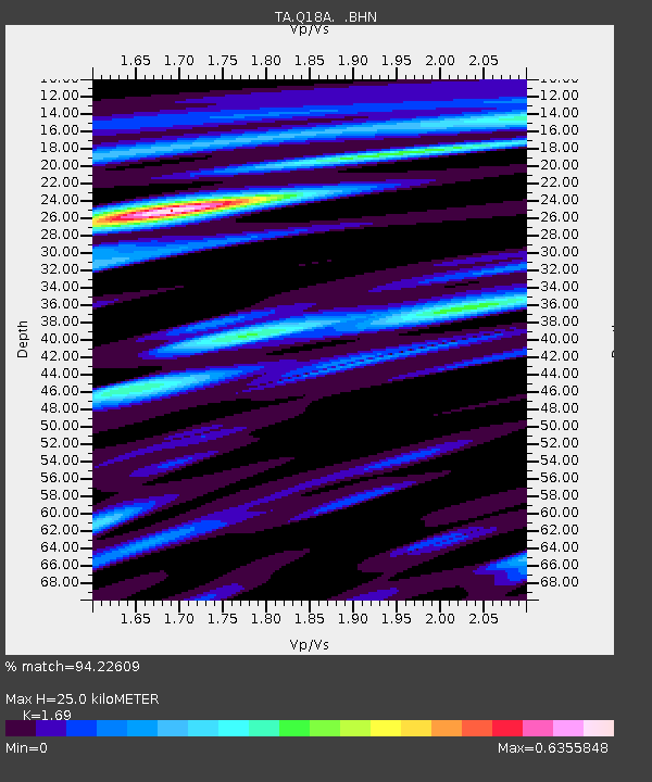
| Estimated Moho Depth: |
25.0 km |
| Estimated Crust Vp/Vs: |
1.69 |
| Assumed Crust Vp: |
6.207 km/s |
| Estimated Crust Vs: |
3.673 km/s |
| Estimated Crust Poisson's Ratio: |
0.23 |
|
| Radial Match: |
94.22609 % |
| Radial Bump: |
400 |
| Transverse Match: |
85.76957 % |
| Transverse Bump: |
400 |
| SOD ConfigId: |
2504 |
| Insert Time: |
2010-03-06 06:00:06.251 +0000 |
| GWidth: |
2.5 |
| Max Bumps: |
400 |
| Tol: |
0.001 |
|

Signal To Noise
| Channel | StoN | STA | LTA |
| TA:Q18A: :BHN:20080719T02:50:58.548999Z | 7.473703 | 5.597291E-7 | 7.4893144E-8 |
| TA:Q18A: :BHE:20080719T02:50:58.548999Z | 4.097776 | 1.461646E-7 | 3.566925E-8 |
| TA:Q18A: :BHZ:20080719T02:50:58.548999Z | 1.9963266 | 1.169299E-7 | 5.857253E-8 |
| Arrivals |
| Ps | 2.9 SECOND |
| PpPs | 11 SECOND |
| PsPs/PpSs | 13 SECOND |


