You are here: Home > Network List > TA - USArray Transportable Network (new EarthScope stations) Stations List
> Station 435B Jarrell, TX, USA > Earthquake Result Viewer
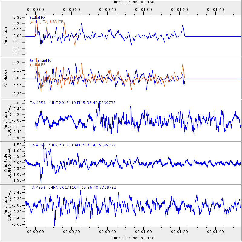
435B Jarrell, TX, USA - Earthquake Result Viewer
*The percent match for this event was below the threshold and hence no stack was calculated.
| Earthquake location: |
Tonga Islands |
| Earthquake latitude/longitude: |
-15.2/-173.3 |
| Earthquake time(UTC): |
2017/11/04 (308) 15:24:31 GMT |
| Earthquake Depth: |
10 km |
| Earthquake Magnitude: |
5.6 mb |
| Earthquake Catalog/Contributor: |
NEIC PDE/us |
|
| Network: |
TA USArray Transportable Network (new EarthScope stations) |
| Station: |
435B Jarrell, TX, USA |
| Lat/Lon: |
30.78 N/97.58 W |
| Elevation: |
248 m |
|
| Distance: |
85.9 deg |
| Az: |
56.752 deg |
| Baz: |
249.762 deg |
| Ray Param: |
$rayparam |
*The percent match for this event was below the threshold and hence was not used in the summary stack. |
|
| Radial Match: |
68.572044 % |
| Radial Bump: |
400 |
| Transverse Match: |
59.2831 % |
| Transverse Bump: |
400 |
| SOD ConfigId: |
13570011 |
| Insert Time: |
2019-04-29 03:03:48.786 +0000 |
| GWidth: |
2.5 |
| Max Bumps: |
400 |
| Tol: |
0.001 |
|
Signal To Noise
| Channel | StoN | STA | LTA |
| TA:435B: :HHZ:20171104T15:36:40.539973Z | 4.276675 | 7.2440605E-7 | 1.6938533E-7 |
| TA:435B: :HHN:20171104T15:36:40.539973Z | 0.91750365 | 1.0274226E-7 | 1.1198023E-7 |
| TA:435B: :HHE:20171104T15:36:40.539973Z | 1.5077546 | 1.9467856E-7 | 1.291182E-7 |
| Arrivals |
| Ps | |
| PpPs | |
| PsPs/PpSs | |


