You are here: Home > Network List > TA - USArray Transportable Network (new EarthScope stations) Stations List
> Station Q18A Rafter H Ranch, Green River, UT, USA > Earthquake Result Viewer
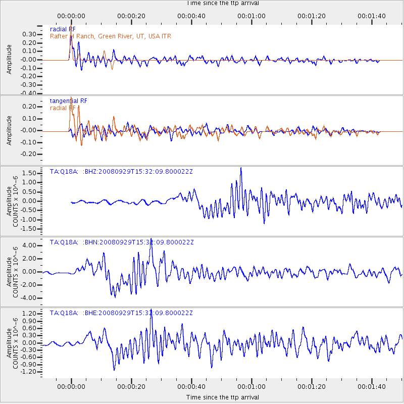
Q18A Rafter H Ranch, Green River, UT, USA - Earthquake Result Viewer
| Earthquake location: |
Kermadec Islands, New Zealand |
| Earthquake latitude/longitude: |
-29.8/-177.7 |
| Earthquake time(UTC): |
2008/09/29 (273) 15:19:31 GMT |
| Earthquake Depth: |
36 km |
| Earthquake Magnitude: |
6.5 MB, 6.7 MS, 7.0 MW, 7.0 MW |
| Earthquake Catalog/Contributor: |
WHDF/NEIC |
|
| Network: |
TA USArray Transportable Network (new EarthScope stations) |
| Station: |
Q18A Rafter H Ranch, Green River, UT, USA |
| Lat/Lon: |
39.10 N/110.13 W |
| Elevation: |
1295 m |
|
| Distance: |
93.0 deg |
| Az: |
46.062 deg |
| Baz: |
233.587 deg |
| Ray Param: |
0.04134082 |
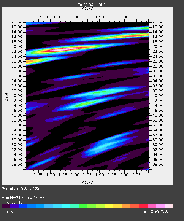
| Estimated Moho Depth: |
21.0 km |
| Estimated Crust Vp/Vs: |
1.75 |
| Assumed Crust Vp: |
6.207 km/s |
| Estimated Crust Vs: |
3.557 km/s |
| Estimated Crust Poisson's Ratio: |
0.26 |
|
| Radial Match: |
93.47462 % |
| Radial Bump: |
400 |
| Transverse Match: |
86.46855 % |
| Transverse Bump: |
400 |
| SOD ConfigId: |
2560 |
| Insert Time: |
2010-03-06 06:00:24.727 +0000 |
| GWidth: |
2.5 |
| Max Bumps: |
400 |
| Tol: |
0.001 |
|
Signal To Noise
| Channel | StoN | STA | LTA |
| TA:Q18A: :BHN:20080929T15:32:09.800022Z | 6.5932145 | 5.232378E-7 | 7.9360056E-8 |
| TA:Q18A: :BHE:20080929T15:32:09.800022Z | 1.4554678 | 8.85754E-8 | 6.0857E-8 |
| TA:Q18A: :BHZ:20080929T15:32:09.800022Z | 2.058834 | 1.4060876E-7 | 6.8295336E-8 |
| Arrivals |
| Ps | 2.6 SECOND |
| PpPs | 9.1 SECOND |
| PsPs/PpSs | 12 SECOND |


