You are here: Home > Network List > TA - USArray Transportable Network (new EarthScope stations) Stations List
> Station F21K Alatna River, AK, USA > Earthquake Result Viewer
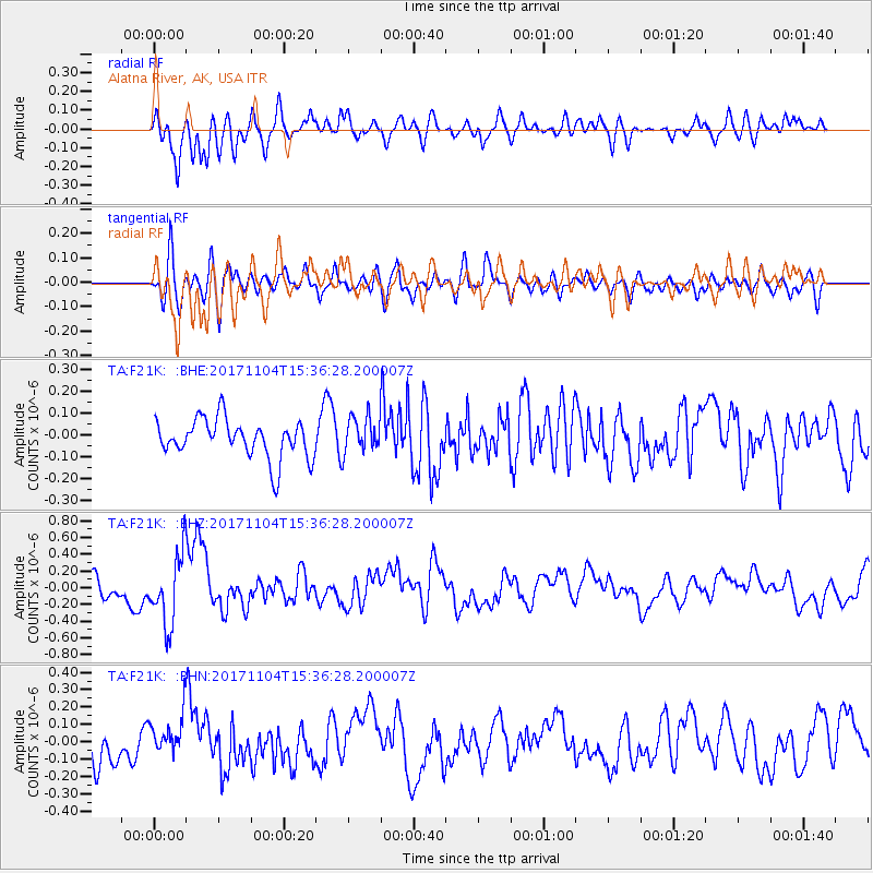
F21K Alatna River, AK, USA - Earthquake Result Viewer
*The percent match for this event was below the threshold and hence no stack was calculated.
| Earthquake location: |
Tonga Islands |
| Earthquake latitude/longitude: |
-15.2/-173.3 |
| Earthquake time(UTC): |
2017/11/04 (308) 15:24:31 GMT |
| Earthquake Depth: |
10 km |
| Earthquake Magnitude: |
5.6 mb |
| Earthquake Catalog/Contributor: |
NEIC PDE/us |
|
| Network: |
TA USArray Transportable Network (new EarthScope stations) |
| Station: |
F21K Alatna River, AK, USA |
| Lat/Lon: |
67.22 N/153.48 W |
| Elevation: |
597 m |
|
| Distance: |
83.5 deg |
| Az: |
7.648 deg |
| Baz: |
199.27 deg |
| Ray Param: |
$rayparam |
*The percent match for this event was below the threshold and hence was not used in the summary stack. |
|
| Radial Match: |
72.4804 % |
| Radial Bump: |
400 |
| Transverse Match: |
51.89949 % |
| Transverse Bump: |
400 |
| SOD ConfigId: |
13570011 |
| Insert Time: |
2019-04-29 03:04:15.926 +0000 |
| GWidth: |
2.5 |
| Max Bumps: |
400 |
| Tol: |
0.001 |
|
Signal To Noise
| Channel | StoN | STA | LTA |
| TA:F21K: :BHZ:20171104T15:36:28.200007Z | 3.791143 | 4.2328185E-7 | 1.11650195E-7 |
| TA:F21K: :BHN:20171104T15:36:28.200007Z | 1.2562139 | 1.1901403E-7 | 9.474026E-8 |
| TA:F21K: :BHE:20171104T15:36:28.200007Z | 0.96284693 | 8.5668155E-8 | 8.8973806E-8 |
| Arrivals |
| Ps | |
| PpPs | |
| PsPs/PpSs | |


