You are here: Home > Network List > TA - USArray Transportable Network (new EarthScope stations) Stations List
> Station Q18A Rafter H Ranch, Green River, UT, USA > Earthquake Result Viewer
Q18A Rafter H Ranch, Green River, UT, USA - Earthquake Result Viewer
| Earthquake location: |
Costa Rica |
| Earthquake latitude/longitude: |
10.2/-84.2 |
| Earthquake time(UTC): |
2009/01/08 (008) 19:21:35 GMT |
| Earthquake Depth: |
14 km |
| Earthquake Magnitude: |
5.7 MB, 6.0 MS, 6.1 MW, 6.1 MW |
| Earthquake Catalog/Contributor: |
WHDF/NEIC |
|
| Network: |
TA USArray Transportable Network (new EarthScope stations) |
| Station: |
Q18A Rafter H Ranch, Green River, UT, USA |
| Lat/Lon: |
39.10 N/110.13 W |
| Elevation: |
1295 m |
|
| Distance: |
37.0 deg |
| Az: |
325.532 deg |
| Baz: |
134.267 deg |
| Ray Param: |
0.07638479 |
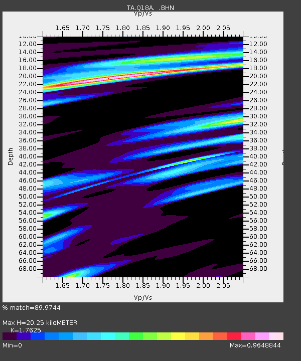
| Estimated Moho Depth: |
20.25 km |
| Estimated Crust Vp/Vs: |
1.76 |
| Assumed Crust Vp: |
6.207 km/s |
| Estimated Crust Vs: |
3.522 km/s |
| Estimated Crust Poisson's Ratio: |
0.26 |
|
| Radial Match: |
89.9744 % |
| Radial Bump: |
400 |
| Transverse Match: |
55.822506 % |
| Transverse Bump: |
400 |
| SOD ConfigId: |
2834 |
| Insert Time: |
2010-03-06 06:00:31.828 +0000 |
| GWidth: |
2.5 |
| Max Bumps: |
400 |
| Tol: |
0.001 |
|
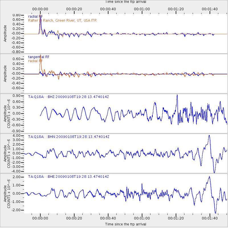
Signal To Noise
| Channel | StoN | STA | LTA |
| TA:Q18A: :BHN:20090108T19:28:13.474014Z | 4.524192 | 5.532747E-7 | 1.2229249E-7 |
| TA:Q18A: :BHE:20090108T19:28:13.474014Z | 0.8158114 | 1.2570511E-7 | 1.5408601E-7 |
| TA:Q18A: :BHZ:20090108T19:28:13.474014Z | 0.99401885 | 1.8622072E-7 | 1.8734123E-7 |
| Arrivals |
| Ps | 2.7 SECOND |
| PpPs | 8.4 SECOND |
| PsPs/PpSs | 11 SECOND |


