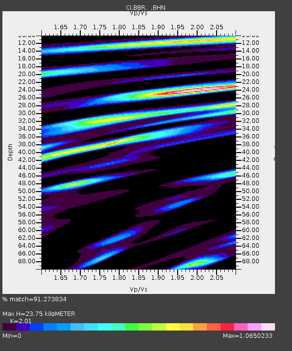
BBR Big Bear Solar Observatory - Earthquake Result Viewer

Earthquake location: Solomon Islands
Earthquake latitude/longitude: -8.5/157.0
Earthquake time(UTC): 2007/04/01 (091) 20:39:56 GMT
Earthquake Depth: 10 km
Earthquake Magnitude: 6.8 MB, 7.9 MS, 8.1 MW, 7.7 ME
Earthquake Catalog/Contributor: WHDF/NEIC
Network: CI Caltech Regional Seismic Network
Station: BBR Big Bear Solar Observatory
Lat/Lon: 34.26 N/116.92 W
Elevation: 2069 m
Distance: 91.4 deg
Az: 55.741 deg
Baz: 260.826 deg
Ray Param: 0.041601397
Estimated Moho Depth: 23.75 km
Estimated Crust Vp/Vs: 2.01
Assumed Crust Vp: 6.276 km/s
Estimated Crust Vs: 3.122 km/s
Estimated Crust Poisson's Ratio: 0.34
Radial Match: 91.273834 %
Radial Bump: 400
Transverse Match: 72.97975 %
Transverse Bump: 400
SOD ConfigId: 2564
Insert Time: 2010-02-26 01:36:04.730 +0000
GWidth: 2.5
Max Bumps: 400
Tol: 0.001

Signal To Noise

ChannelStoNSTALTA
CI:BBR: :BHN:20070401T20:52:31.088008Z1.20401431.8227588E-71.5139013E-7
CI:BBR: :BHE:20070401T20:52:31.088008Z1.64157142.310765E-71.4076544E-7
CI:BBR: :BHZ:20070401T20:52:31.088008Z5.291151.2685759E-62.397543E-7
Arrivals
Ps3.9 SECOND
PpPs11 SECOND
PsPs/PpSs15 SECOND