You are here: Home > Network List > TA - USArray Transportable Network (new EarthScope stations) Stations List
> Station H31M Peel River, Yukon, CAN > Earthquake Result Viewer
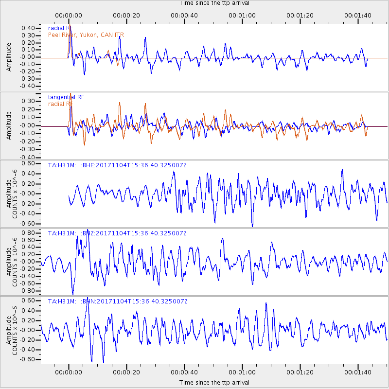
H31M Peel River, Yukon, CAN - Earthquake Result Viewer
*The percent match for this event was below the threshold and hence no stack was calculated.
| Earthquake location: |
Tonga Islands |
| Earthquake latitude/longitude: |
-15.2/-173.3 |
| Earthquake time(UTC): |
2017/11/04 (308) 15:24:31 GMT |
| Earthquake Depth: |
10 km |
| Earthquake Magnitude: |
5.6 mb |
| Earthquake Catalog/Contributor: |
NEIC PDE/us |
|
| Network: |
TA USArray Transportable Network (new EarthScope stations) |
| Station: |
H31M Peel River, Yukon, CAN |
| Lat/Lon: |
65.81 N/134.34 W |
| Elevation: |
642 m |
|
| Distance: |
85.9 deg |
| Az: |
15.07 deg |
| Baz: |
217.525 deg |
| Ray Param: |
$rayparam |
*The percent match for this event was below the threshold and hence was not used in the summary stack. |
|
| Radial Match: |
61.166496 % |
| Radial Bump: |
400 |
| Transverse Match: |
57.18684 % |
| Transverse Bump: |
400 |
| SOD ConfigId: |
13570011 |
| Insert Time: |
2019-04-29 03:04:45.239 +0000 |
| GWidth: |
2.5 |
| Max Bumps: |
400 |
| Tol: |
0.001 |
|
Signal To Noise
| Channel | StoN | STA | LTA |
| TA:H31M: :BHZ:20171104T15:36:40.325007Z | 3.7303543 | 4.407672E-7 | 1.18156926E-7 |
| TA:H31M: :BHN:20171104T15:36:40.325007Z | 1.4927397 | 1.8323183E-7 | 1.2274869E-7 |
| TA:H31M: :BHE:20171104T15:36:40.325007Z | 0.9919701 | 1.12682805E-7 | 1.1359496E-7 |
| Arrivals |
| Ps | |
| PpPs | |
| PsPs/PpSs | |


