You are here: Home > Network List > TA - USArray Transportable Network (new EarthScope stations) Stations List
> Station Q18A Rafter H Ranch, Green River, UT, USA > Earthquake Result Viewer
Q18A Rafter H Ranch, Green River, UT, USA - Earthquake Result Viewer
| Earthquake location: |
Northern Chile |
| Earthquake latitude/longitude: |
-22.2/-69.9 |
| Earthquake time(UTC): |
2007/11/14 (318) 15:40:50 GMT |
| Earthquake Depth: |
40 km |
| Earthquake Magnitude: |
6.7 MB, 7.4 MS, 7.7 MW, 7.4 ME |
| Earthquake Catalog/Contributor: |
WHDF/NEIC |
|
| Network: |
TA USArray Transportable Network (new EarthScope stations) |
| Station: |
Q18A Rafter H Ranch, Green River, UT, USA |
| Lat/Lon: |
39.10 N/110.13 W |
| Elevation: |
1295 m |
|
| Distance: |
71.7 deg |
| Az: |
328.035 deg |
| Baz: |
140.924 deg |
| Ray Param: |
0.054075964 |
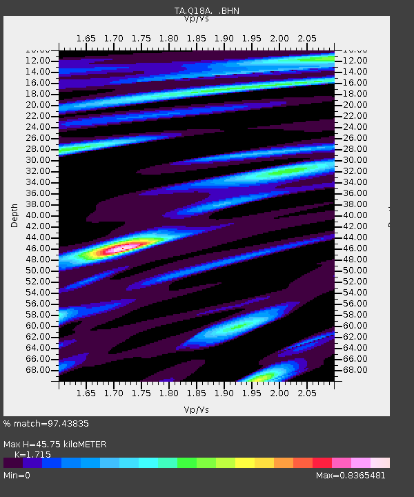
| Estimated Moho Depth: |
45.75 km |
| Estimated Crust Vp/Vs: |
1.72 |
| Assumed Crust Vp: |
6.207 km/s |
| Estimated Crust Vs: |
3.619 km/s |
| Estimated Crust Poisson's Ratio: |
0.24 |
|
| Radial Match: |
97.43835 % |
| Radial Bump: |
400 |
| Transverse Match: |
90.07199 % |
| Transverse Bump: |
400 |
| SOD ConfigId: |
2564 |
| Insert Time: |
2010-03-06 06:00:46.815 +0000 |
| GWidth: |
2.5 |
| Max Bumps: |
400 |
| Tol: |
0.001 |
|

Signal To Noise
| Channel | StoN | STA | LTA |
| TA:Q18A: :BHN:20071114T15:51:37.524019Z | 15.697529 | 1.6227929E-6 | 1.0337887E-7 |
| TA:Q18A: :BHE:20071114T15:51:37.524019Z | 6.961421 | 1.1934407E-6 | 1.7143634E-7 |
| TA:Q18A: :BHZ:20071114T15:51:37.524019Z | 18.791395 | 5.2902783E-6 | 2.815266E-7 |
| Arrivals |
| Ps | 5.5 SECOND |
| PpPs | 19 SECOND |
| PsPs/PpSs | 25 SECOND |


