You are here: Home > Network List > TA - USArray Transportable Network (new EarthScope stations) Stations List
> Station R17K Ugashik Creek, AK, USA > Earthquake Result Viewer
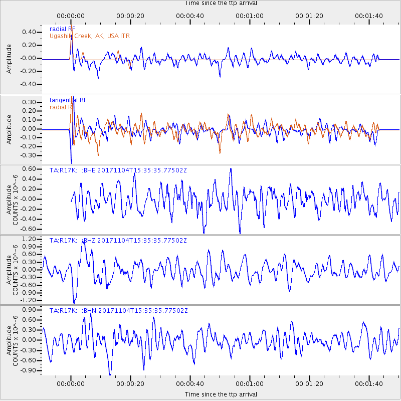
R17K Ugashik Creek, AK, USA - Earthquake Result Viewer
*The percent match for this event was below the threshold and hence no stack was calculated.
| Earthquake location: |
Tonga Islands |
| Earthquake latitude/longitude: |
-15.2/-173.3 |
| Earthquake time(UTC): |
2017/11/04 (308) 15:24:31 GMT |
| Earthquake Depth: |
10 km |
| Earthquake Magnitude: |
5.6 mb |
| Earthquake Catalog/Contributor: |
NEIC PDE/us |
|
| Network: |
TA USArray Transportable Network (new EarthScope stations) |
| Station: |
R17K Ugashik Creek, AK, USA |
| Lat/Lon: |
57.64 N/156.39 W |
| Elevation: |
273 m |
|
| Distance: |
73.9 deg |
| Az: |
9.391 deg |
| Baz: |
197.033 deg |
| Ray Param: |
$rayparam |
*The percent match for this event was below the threshold and hence was not used in the summary stack. |
|
| Radial Match: |
66.22888 % |
| Radial Bump: |
400 |
| Transverse Match: |
60.787373 % |
| Transverse Bump: |
400 |
| SOD ConfigId: |
13570011 |
| Insert Time: |
2019-04-29 03:05:54.238 +0000 |
| GWidth: |
2.5 |
| Max Bumps: |
400 |
| Tol: |
0.001 |
|
Signal To Noise
| Channel | StoN | STA | LTA |
| TA:R17K: :BHZ:20171104T15:35:35.77502Z | 3.3340433 | 7.7532786E-7 | 2.3254884E-7 |
| TA:R17K: :BHN:20171104T15:35:35.77502Z | 1.2611718 | 2.9242364E-7 | 2.318666E-7 |
| TA:R17K: :BHE:20171104T15:35:35.77502Z | 0.9963233 | 2.2079385E-7 | 2.2160864E-7 |
| Arrivals |
| Ps | |
| PpPs | |
| PsPs/PpSs | |


