You are here: Home > Network List > TA - USArray Transportable Network (new EarthScope stations) Stations List
> Station Q18A Rafter H Ranch, Green River, UT, USA > Earthquake Result Viewer
Q18A Rafter H Ranch, Green River, UT, USA - Earthquake Result Viewer
| Earthquake location: |
Near West Coast Of Honshu, Japan |
| Earthquake latitude/longitude: |
37.5/138.4 |
| Earthquake time(UTC): |
2007/07/16 (197) 01:13:22 GMT |
| Earthquake Depth: |
12 km |
| Earthquake Magnitude: |
6.5 MB, 6.4 MS, 6.6 MW, 6.5 MW |
| Earthquake Catalog/Contributor: |
WHDF/NEIC |
|
| Network: |
TA USArray Transportable Network (new EarthScope stations) |
| Station: |
Q18A Rafter H Ranch, Green River, UT, USA |
| Lat/Lon: |
39.10 N/110.13 W |
| Elevation: |
1295 m |
|
| Distance: |
81.1 deg |
| Az: |
47.157 deg |
| Baz: |
311.486 deg |
| Ray Param: |
0.04783964 |
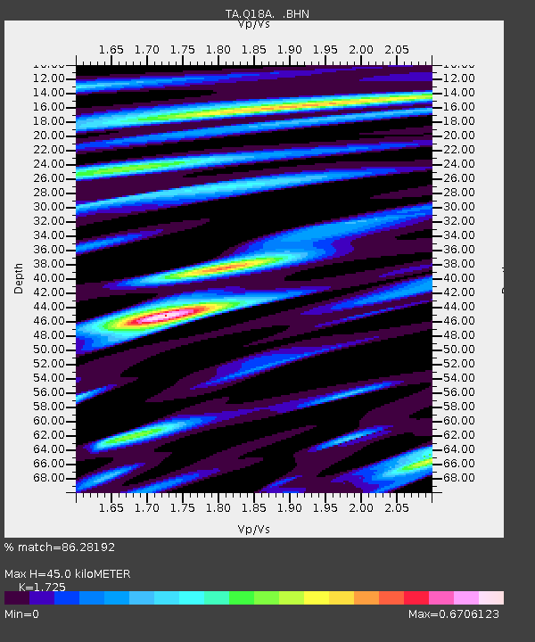
| Estimated Moho Depth: |
45.0 km |
| Estimated Crust Vp/Vs: |
1.73 |
| Assumed Crust Vp: |
6.207 km/s |
| Estimated Crust Vs: |
3.598 km/s |
| Estimated Crust Poisson's Ratio: |
0.25 |
|
| Radial Match: |
86.28192 % |
| Radial Bump: |
400 |
| Transverse Match: |
85.249 % |
| Transverse Bump: |
400 |
| SOD ConfigId: |
2564 |
| Insert Time: |
2010-03-06 06:01:17.758 +0000 |
| GWidth: |
2.5 |
| Max Bumps: |
400 |
| Tol: |
0.001 |
|

Signal To Noise
| Channel | StoN | STA | LTA |
| TA:Q18A: :BHN:20070716T01:25:05.799016Z | 8.003066 | 3.9231256E-7 | 4.9020286E-8 |
| TA:Q18A: :BHE:20070716T01:25:05.799016Z | 9.224057 | 4.019308E-7 | 4.357419E-8 |
| TA:Q18A: :BHZ:20070716T01:25:05.799016Z | 38.18287 | 2.1545682E-6 | 5.6427613E-8 |
| Arrivals |
| Ps | 5.4 SECOND |
| PpPs | 19 SECOND |
| PsPs/PpSs | 25 SECOND |


