You are here: Home > Network List > TA - USArray Transportable Network (new EarthScope stations) Stations List
> Station Q18A Rafter H Ranch, Green River, UT, USA > Earthquake Result Viewer
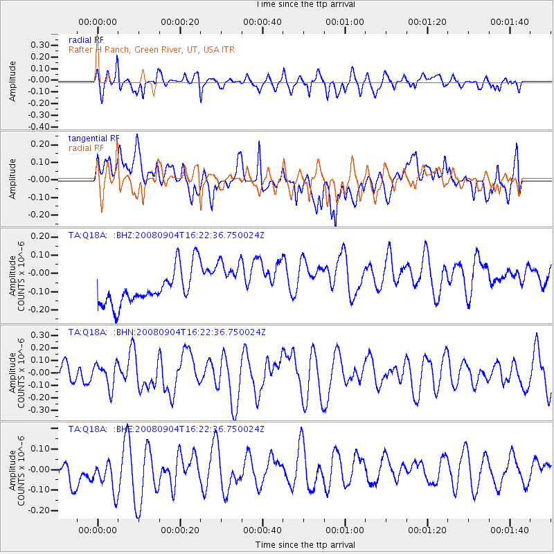
Q18A Rafter H Ranch, Green River, UT, USA - Earthquake Result Viewer
*The percent match for this event was below the threshold and hence no stack was calculated.
| Earthquake location: |
Kermadec Islands Region |
| Earthquake latitude/longitude: |
-31.6/-177.8 |
| Earthquake time(UTC): |
2008/09/04 (248) 16:09:51 GMT |
| Earthquake Depth: |
26 km |
| Earthquake Magnitude: |
5.5 MB, 5.9 MS, 5.8 MW, 5.7 MW |
| Earthquake Catalog/Contributor: |
WHDF/NEIC |
|
| Network: |
TA USArray Transportable Network (new EarthScope stations) |
| Station: |
Q18A Rafter H Ranch, Green River, UT, USA |
| Lat/Lon: |
39.10 N/110.13 W |
| Elevation: |
1295 m |
|
| Distance: |
94.3 deg |
| Az: |
46.201 deg |
| Baz: |
232.365 deg |
| Ray Param: |
$rayparam |
*The percent match for this event was below the threshold and hence was not used in the summary stack. |
|
| Radial Match: |
48.045696 % |
| Radial Bump: |
400 |
| Transverse Match: |
39.469624 % |
| Transverse Bump: |
400 |
| SOD ConfigId: |
2504 |
| Insert Time: |
2010-03-06 06:01:42.904 +0000 |
| GWidth: |
2.5 |
| Max Bumps: |
400 |
| Tol: |
0.001 |
|
Signal To Noise
| Channel | StoN | STA | LTA |
| TA:Q18A: :BHN:20080904T16:22:36.750024Z | 1.2467964 | 9.9338166E-8 | 7.9674734E-8 |
| TA:Q18A: :BHE:20080904T16:22:36.750024Z | 1.1448992 | 1.2362612E-7 | 1.0797991E-7 |
| TA:Q18A: :BHZ:20080904T16:22:36.750024Z | 1.3272537 | 1.2573751E-7 | 9.473509E-8 |
| Arrivals |
| Ps | |
| PpPs | |
| PsPs/PpSs | |


