You are here: Home > Network List > AZ - ANZA Regional Network Stations List
> Station SMER AZ.SMER > Earthquake Result Viewer
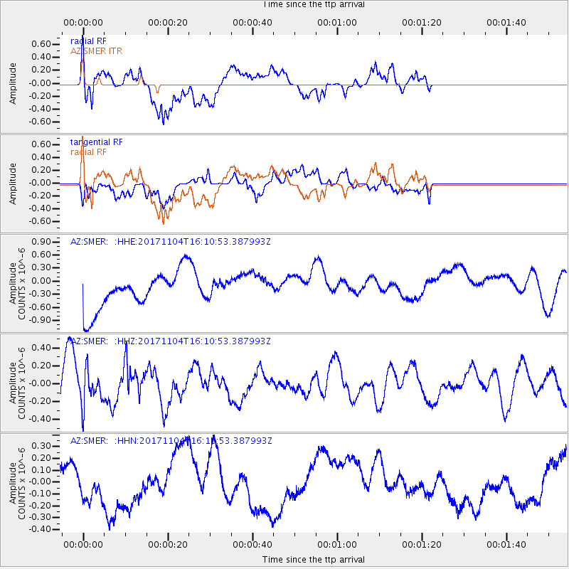
SMER AZ.SMER - Earthquake Result Viewer
*The percent match for this event was below the threshold and hence no stack was calculated.
| Earthquake location: |
Loyalty Islands |
| Earthquake latitude/longitude: |
-21.8/168.9 |
| Earthquake time(UTC): |
2017/11/04 (308) 15:58:28 GMT |
| Earthquake Depth: |
10 km |
| Earthquake Magnitude: |
5.2 Mww |
| Earthquake Catalog/Contributor: |
NEIC PDE/us |
|
| Network: |
AZ ANZA Regional Network |
| Station: |
SMER AZ.SMER |
| Lat/Lon: |
33.46 N/117.17 W |
| Elevation: |
355 m |
|
| Distance: |
89.3 deg |
| Az: |
53.451 deg |
| Baz: |
243.287 deg |
| Ray Param: |
$rayparam |
*The percent match for this event was below the threshold and hence was not used in the summary stack. |
|
| Radial Match: |
54.03683 % |
| Radial Bump: |
400 |
| Transverse Match: |
47.60047 % |
| Transverse Bump: |
400 |
| SOD ConfigId: |
13570011 |
| Insert Time: |
2019-04-29 03:08:50.846 +0000 |
| GWidth: |
2.5 |
| Max Bumps: |
400 |
| Tol: |
0.001 |
|
Signal To Noise
| Channel | StoN | STA | LTA |
| AZ:SMER: :HHZ:20171104T16:10:53.387993Z | 0.7838721 | 1.9184633E-7 | 2.4474187E-7 |
| AZ:SMER: :HHN:20171104T16:10:53.387993Z | 0.76696306 | 1.7239475E-7 | 2.2477582E-7 |
| AZ:SMER: :HHE:20171104T16:10:53.387993Z | 0.44550285 | 1.8716594E-7 | 4.201229E-7 |
| Arrivals |
| Ps | |
| PpPs | |
| PsPs/PpSs | |


