You are here: Home > Network List > TA - USArray Transportable Network (new EarthScope stations) Stations List
> Station Q18A Rafter H Ranch, Green River, UT, USA > Earthquake Result Viewer
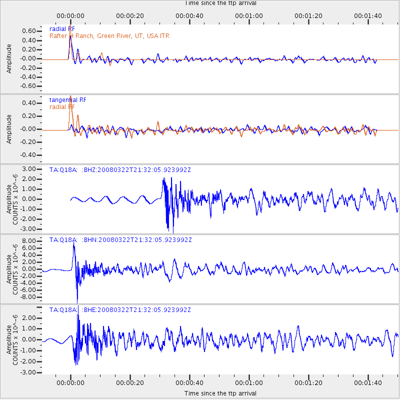
Q18A Rafter H Ranch, Green River, UT, USA - Earthquake Result Viewer
*The percent match for this event was below the threshold and hence no stack was calculated.
| Earthquake location: |
Andreanof Islands, Aleutian Is. |
| Earthquake latitude/longitude: |
52.2/-178.7 |
| Earthquake time(UTC): |
2008/03/22 (082) 21:24:11 GMT |
| Earthquake Depth: |
132 km |
| Earthquake Magnitude: |
5.8 MB, 6.2 MW, 6.1 MW |
| Earthquake Catalog/Contributor: |
WHDF/NEIC |
|
| Network: |
TA USArray Transportable Network (new EarthScope stations) |
| Station: |
Q18A Rafter H Ranch, Green River, UT, USA |
| Lat/Lon: |
39.10 N/110.13 W |
| Elevation: |
1295 m |
|
| Distance: |
47.9 deg |
| Az: |
77.321 deg |
| Baz: |
309.454 deg |
| Ray Param: |
$rayparam |
*The percent match for this event was below the threshold and hence was not used in the summary stack. |
|
| Radial Match: |
78.76629 % |
| Radial Bump: |
400 |
| Transverse Match: |
63.659492 % |
| Transverse Bump: |
400 |
| SOD ConfigId: |
2504 |
| Insert Time: |
2010-03-06 06:01:59.558 +0000 |
| GWidth: |
2.5 |
| Max Bumps: |
400 |
| Tol: |
0.001 |
|
Signal To Noise
| Channel | StoN | STA | LTA |
| TA:Q18A: :BHN:20080322T21:32:05.923992Z | 16.656324 | 3.1731438E-6 | 1.9050684E-7 |
| TA:Q18A: :BHE:20080322T21:32:05.923992Z | 6.6229553 | 1.0344627E-6 | 1.5619351E-7 |
| TA:Q18A: :BHZ:20080322T21:32:05.923992Z | 5.8227315 | 1.2918273E-6 | 2.2185934E-7 |
| Arrivals |
| Ps | |
| PpPs | |
| PsPs/PpSs | |


