You are here: Home > Network List > AZ - ANZA Regional Network Stations List
> Station SMER AZ.SMER > Earthquake Result Viewer
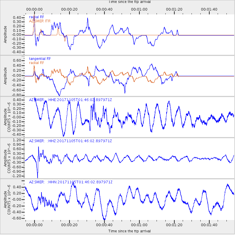
SMER AZ.SMER - Earthquake Result Viewer
*The percent match for this event was below the threshold and hence no stack was calculated.
| Earthquake location: |
Fiji Islands Region |
| Earthquake latitude/longitude: |
-18.6/-177.7 |
| Earthquake time(UTC): |
2017/11/05 (309) 01:35:28 GMT |
| Earthquake Depth: |
483 km |
| Earthquake Magnitude: |
5.5 Mww |
| Earthquake Catalog/Contributor: |
NEIC PDE/us |
|
| Network: |
AZ ANZA Regional Network |
| Station: |
SMER AZ.SMER |
| Lat/Lon: |
33.46 N/117.17 W |
| Elevation: |
355 m |
|
| Distance: |
77.6 deg |
| Az: |
48.209 deg |
| Baz: |
237.736 deg |
| Ray Param: |
$rayparam |
*The percent match for this event was below the threshold and hence was not used in the summary stack. |
|
| Radial Match: |
52.755043 % |
| Radial Bump: |
400 |
| Transverse Match: |
62.32523 % |
| Transverse Bump: |
400 |
| SOD ConfigId: |
13570011 |
| Insert Time: |
2019-04-29 03:13:24.509 +0000 |
| GWidth: |
2.5 |
| Max Bumps: |
400 |
| Tol: |
0.001 |
|
Signal To Noise
| Channel | StoN | STA | LTA |
| AZ:SMER: :HHZ:20171105T01:46:02.897971Z | 2.7816892 | 4.2938981E-7 | 1.5436298E-7 |
| AZ:SMER: :HHN:20171105T01:46:02.897971Z | 0.9406639 | 2.0868356E-7 | 2.218471E-7 |
| AZ:SMER: :HHE:20171105T01:46:02.897971Z | 0.78945106 | 1.8318057E-7 | 2.3203538E-7 |
| Arrivals |
| Ps | |
| PpPs | |
| PsPs/PpSs | |


