You are here: Home > Network List > US - United States National Seismic Network Stations List
> Station HAWA Hanford, Washington, USA > Earthquake Result Viewer
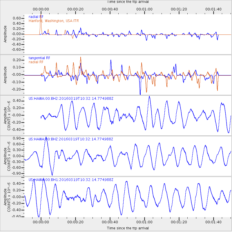
HAWA Hanford, Washington, USA - Earthquake Result Viewer
*The percent match for this event was below the threshold and hence no stack was calculated.
| Earthquake location: |
Off Coast Of Central America |
| Earthquake latitude/longitude: |
11.9/-88.8 |
| Earthquake time(UTC): |
2016/03/19 (079) 10:24:45 GMT |
| Earthquake Depth: |
10 km |
| Earthquake Magnitude: |
5.6 MWC, 5.6 MWC, 5.6 MWW |
| Earthquake Catalog/Contributor: |
NEIC PDE/NEIC COMCAT |
|
| Network: |
US United States National Seismic Network |
| Station: |
HAWA Hanford, Washington, USA |
| Lat/Lon: |
46.39 N/119.53 W |
| Elevation: |
364 m |
|
| Distance: |
43.1 deg |
| Az: |
328.817 deg |
| Baz: |
132.921 deg |
| Ray Param: |
$rayparam |
*The percent match for this event was below the threshold and hence was not used in the summary stack. |
|
| Radial Match: |
52.363613 % |
| Radial Bump: |
400 |
| Transverse Match: |
40.347427 % |
| Transverse Bump: |
276 |
| SOD ConfigId: |
1475611 |
| Insert Time: |
2016-04-14 11:08:14.928 +0000 |
| GWidth: |
2.5 |
| Max Bumps: |
400 |
| Tol: |
0.001 |
|
Signal To Noise
| Channel | StoN | STA | LTA |
| US:HAWA:00:BHZ:20160319T10:32:14.774988Z | 2.721476 | 5.856979E-7 | 2.1521332E-7 |
| US:HAWA:00:BH1:20160319T10:32:14.774988Z | 2.9654636 | 3.6769447E-7 | 1.2399224E-7 |
| US:HAWA:00:BH2:20160319T10:32:14.774988Z | 1.3832877 | 2.697403E-7 | 1.9499943E-7 |
| Arrivals |
| Ps | |
| PpPs | |
| PsPs/PpSs | |


