You are here: Home > Network List > TA - USArray Transportable Network (new EarthScope stations) Stations List
> Station L15K Ungalak Mountain, AK, USA > Earthquake Result Viewer
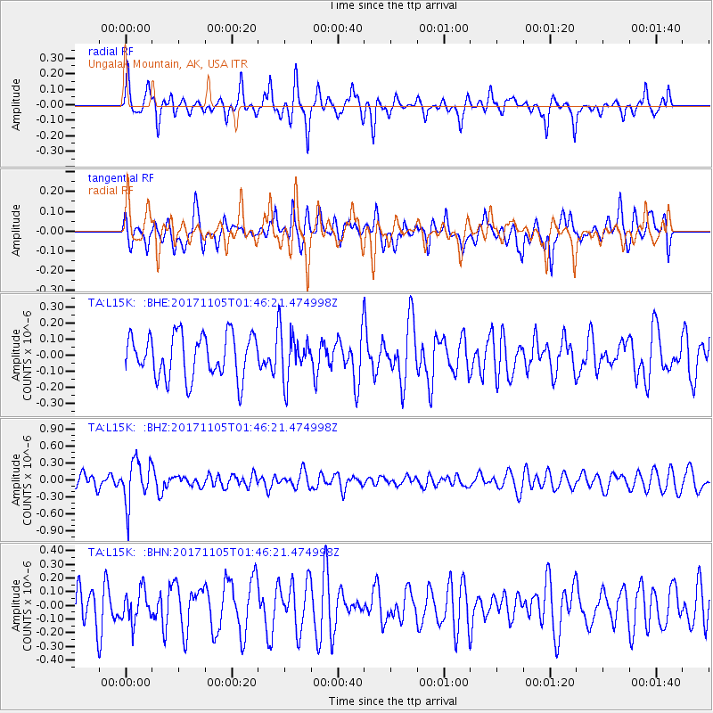
L15K Ungalak Mountain, AK, USA - Earthquake Result Viewer
*The percent match for this event was below the threshold and hence no stack was calculated.
| Earthquake location: |
Fiji Islands Region |
| Earthquake latitude/longitude: |
-18.6/-177.7 |
| Earthquake time(UTC): |
2017/11/05 (309) 01:35:28 GMT |
| Earthquake Depth: |
483 km |
| Earthquake Magnitude: |
5.5 Mww |
| Earthquake Catalog/Contributor: |
NEIC PDE/us |
|
| Network: |
TA USArray Transportable Network (new EarthScope stations) |
| Station: |
L15K Ungalak Mountain, AK, USA |
| Lat/Lon: |
61.68 N/161.49 W |
| Elevation: |
219 m |
|
| Distance: |
81.1 deg |
| Az: |
7.767 deg |
| Baz: |
195.586 deg |
| Ray Param: |
$rayparam |
*The percent match for this event was below the threshold and hence was not used in the summary stack. |
|
| Radial Match: |
59.92796 % |
| Radial Bump: |
355 |
| Transverse Match: |
48.41176 % |
| Transverse Bump: |
400 |
| SOD ConfigId: |
13570011 |
| Insert Time: |
2019-04-29 03:17:33.798 +0000 |
| GWidth: |
2.5 |
| Max Bumps: |
400 |
| Tol: |
0.001 |
|
Signal To Noise
| Channel | StoN | STA | LTA |
| TA:L15K: :BHZ:20171105T01:46:21.474998Z | 2.5809324 | 3.860791E-7 | 1.49589E-7 |
| TA:L15K: :BHN:20171105T01:46:21.474998Z | 0.9185758 | 1.1326744E-7 | 1.2330766E-7 |
| TA:L15K: :BHE:20171105T01:46:21.474998Z | 1.0741168 | 1.43245E-7 | 1.3336073E-7 |
| Arrivals |
| Ps | |
| PpPs | |
| PsPs/PpSs | |


