You are here: Home > Network List > TA - USArray Transportable Network (new EarthScope stations) Stations List
> Station Q18A Rafter H Ranch, Green River, UT, USA > Earthquake Result Viewer
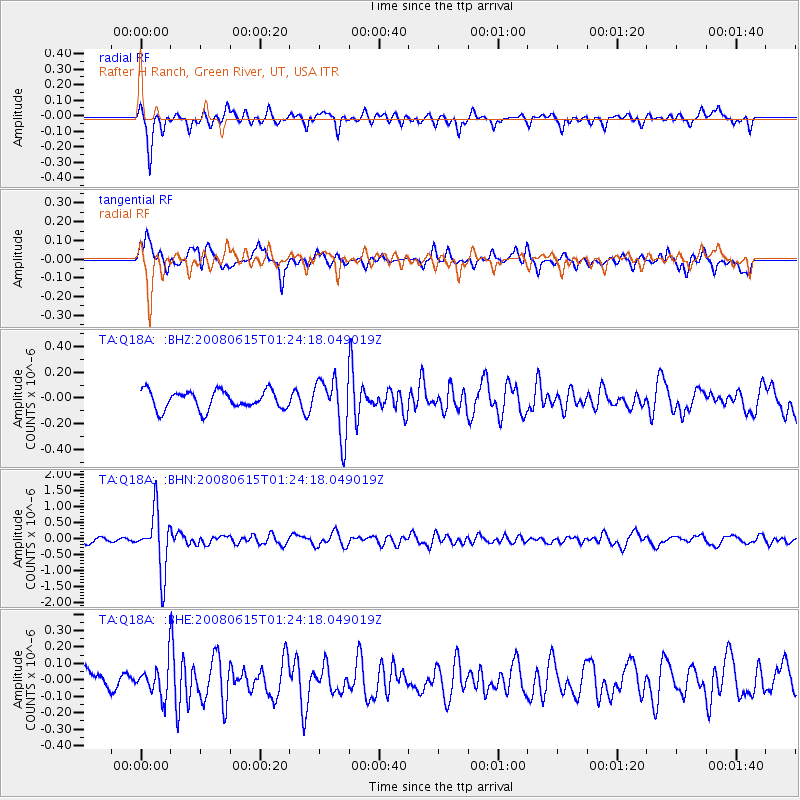
Q18A Rafter H Ranch, Green River, UT, USA - Earthquake Result Viewer
*The percent match for this event was below the threshold and hence no stack was calculated.
| Earthquake location: |
Fiji Islands Region |
| Earthquake latitude/longitude: |
-17.7/-179.7 |
| Earthquake time(UTC): |
2008/06/15 (167) 01:13:11 GMT |
| Earthquake Depth: |
611 km |
| Earthquake Magnitude: |
5.5 MB, 5.9 MW, 5.9 MW |
| Earthquake Catalog/Contributor: |
WHDF/NEIC |
|
| Network: |
TA USArray Transportable Network (new EarthScope stations) |
| Station: |
Q18A Rafter H Ranch, Green River, UT, USA |
| Lat/Lon: |
39.10 N/110.13 W |
| Elevation: |
1295 m |
|
| Distance: |
86.1 deg |
| Az: |
46.97 deg |
| Baz: |
243.558 deg |
| Ray Param: |
$rayparam |
*The percent match for this event was below the threshold and hence was not used in the summary stack. |
|
| Radial Match: |
75.48652 % |
| Radial Bump: |
365 |
| Transverse Match: |
61.817043 % |
| Transverse Bump: |
358 |
| SOD ConfigId: |
2504 |
| Insert Time: |
2010-03-06 06:03:08.551 +0000 |
| GWidth: |
2.5 |
| Max Bumps: |
400 |
| Tol: |
0.001 |
|
Signal To Noise
| Channel | StoN | STA | LTA |
| TA:Q18A: :BHN:20080615T01:24:18.049019Z | 10.688078 | 9.29862E-7 | 8.6999925E-8 |
| TA:Q18A: :BHE:20080615T01:24:18.049019Z | 1.0343348 | 9.672806E-8 | 9.3517166E-8 |
| TA:Q18A: :BHZ:20080615T01:24:18.049019Z | 3.0860827 | 2.2105347E-7 | 7.162915E-8 |
| Arrivals |
| Ps | |
| PpPs | |
| PsPs/PpSs | |


