You are here: Home > Network List > TA - USArray Transportable Network (new EarthScope stations) Stations List
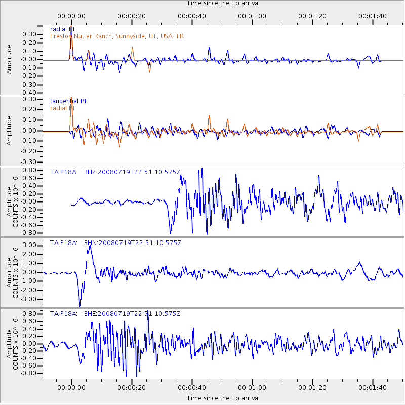
> Station P18A Preston Nutter Ranch, Sunnyside, UT, USA > Earthquake Result Viewer
P18A Preston Nutter Ranch, Sunnyside, UT, USA - Earthquake Result Viewer
| Earthquake location: |
Fiji Islands Region |
| Earthquake latitude/longitude: |
-17.3/-177.3 |
| Earthquake time(UTC): |
2008/07/19 (201) 22:39:52 GMT |
| Earthquake Depth: |
391 km |
| Earthquake Magnitude: |
5.9 MB, 6.4 MW, 6.4 MW |
| Earthquake Catalog/Contributor: |
WHDF/NEIC |
|
| Network: |
TA USArray Transportable Network (new EarthScope stations) |
| Station: |
P18A Preston Nutter Ranch, Sunnyside, UT, USA |
| Lat/Lon: |
39.63 N/110.25 W |
| Elevation: |
2743 m |
|
| Distance: |
84.3 deg |
| Az: |
45.626 deg |
| Baz: |
242.129 deg |
| Ray Param: |
0.044535667 |
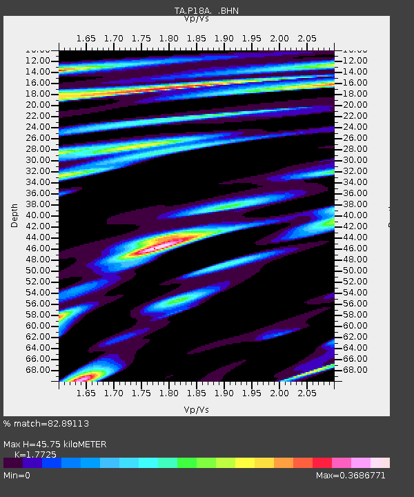
| Estimated Moho Depth: |
45.75 km |
| Estimated Crust Vp/Vs: |
1.77 |
| Assumed Crust Vp: |
6.207 km/s |
| Estimated Crust Vs: |
3.502 km/s |
| Estimated Crust Poisson's Ratio: |
0.27 |
|
| Radial Match: |
82.89113 % |
| Radial Bump: |
400 |
| Transverse Match: |
65.54567 % |
| Transverse Bump: |
400 |
| SOD ConfigId: |
2504 |
| Insert Time: |
2010-03-06 06:03:39.629 +0000 |
| GWidth: |
2.5 |
| Max Bumps: |
400 |
| Tol: |
0.001 |
|
Signal To Noise
| Channel | StoN | STA | LTA |
| TA:P18A: :BHN:20080719T22:51:10.575Z | 14.7051525 | 1.4696153E-6 | 9.99388E-8 |
| TA:P18A: :BHE:20080719T22:51:10.575Z | 3.025902 | 2.3302884E-7 | 7.7011364E-8 |
| TA:P18A: :BHZ:20080719T22:51:10.575Z | 8.344988 | 3.3903208E-7 | 4.062703E-8 |
| Arrivals |
| Ps | 5.8 SECOND |
| PpPs | 20 SECOND |
| PsPs/PpSs | 26 SECOND |


