You are here: Home > Network List > TA - USArray Transportable Network (new EarthScope stations) Stations List
> Station P18A Preston Nutter Ranch, Sunnyside, UT, USA > Earthquake Result Viewer
P18A Preston Nutter Ranch, Sunnyside, UT, USA - Earthquake Result Viewer
| Earthquake location: |
Kuril Islands |
| Earthquake latitude/longitude: |
49.9/156.4 |
| Earthquake time(UTC): |
2008/08/04 (217) 04:42:14 GMT |
| Earthquake Depth: |
77 km |
| Earthquake Magnitude: |
5.6 MB, 5.8 MW, 5.7 MW |
| Earthquake Catalog/Contributor: |
WHDF/NEIC |
|
| Network: |
TA USArray Transportable Network (new EarthScope stations) |
| Station: |
P18A Preston Nutter Ranch, Sunnyside, UT, USA |
| Lat/Lon: |
39.63 N/110.25 W |
| Elevation: |
2743 m |
|
| Distance: |
62.9 deg |
| Az: |
59.959 deg |
| Baz: |
313.486 deg |
| Ray Param: |
0.059699096 |
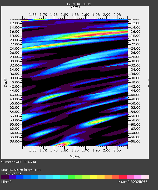
| Estimated Moho Depth: |
69.75 km |
| Estimated Crust Vp/Vs: |
1.77 |
| Assumed Crust Vp: |
6.207 km/s |
| Estimated Crust Vs: |
3.502 km/s |
| Estimated Crust Poisson's Ratio: |
0.27 |
|
| Radial Match: |
80.304634 % |
| Radial Bump: |
400 |
| Transverse Match: |
66.83835 % |
| Transverse Bump: |
366 |
| SOD ConfigId: |
2504 |
| Insert Time: |
2010-03-06 06:03:44.790 +0000 |
| GWidth: |
2.5 |
| Max Bumps: |
400 |
| Tol: |
0.001 |
|
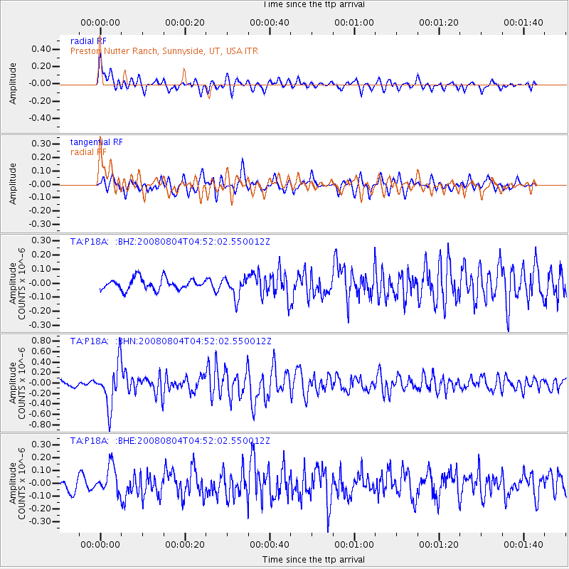
Signal To Noise
| Channel | StoN | STA | LTA |
| TA:P18A: :BHN:20080804T04:52:02.550012Z | 6.933954 | 4.232258E-7 | 6.103672E-8 |
| TA:P18A: :BHE:20080804T04:52:02.550012Z | 2.3173573 | 1.120895E-7 | 4.836954E-8 |
| TA:P18A: :BHZ:20080804T04:52:02.550012Z | 1.8832521 | 7.4216885E-8 | 3.9408896E-8 |
| Arrivals |
| Ps | 9.0 SECOND |
| PpPs | 30 SECOND |
| PsPs/PpSs | 39 SECOND |


