You are here: Home > Network List > TA - USArray Transportable Network (new EarthScope stations) Stations List
> Station P18A Preston Nutter Ranch, Sunnyside, UT, USA > Earthquake Result Viewer
P18A Preston Nutter Ranch, Sunnyside, UT, USA - Earthquake Result Viewer
| Earthquake location: |
East Of Kuril Islands |
| Earthquake latitude/longitude: |
46.9/155.2 |
| Earthquake time(UTC): |
2009/01/15 (015) 17:49:39 GMT |
| Earthquake Depth: |
36 km |
| Earthquake Magnitude: |
6.9 MB, 7.5 MS, 7.4 MW, 7.4 MW |
| Earthquake Catalog/Contributor: |
WHDF/NEIC |
|
| Network: |
TA USArray Transportable Network (new EarthScope stations) |
| Station: |
P18A Preston Nutter Ranch, Sunnyside, UT, USA |
| Lat/Lon: |
39.63 N/110.25 W |
| Elevation: |
2743 m |
|
| Distance: |
65.2 deg |
| Az: |
58.001 deg |
| Baz: |
311.098 deg |
| Ray Param: |
0.058370903 |
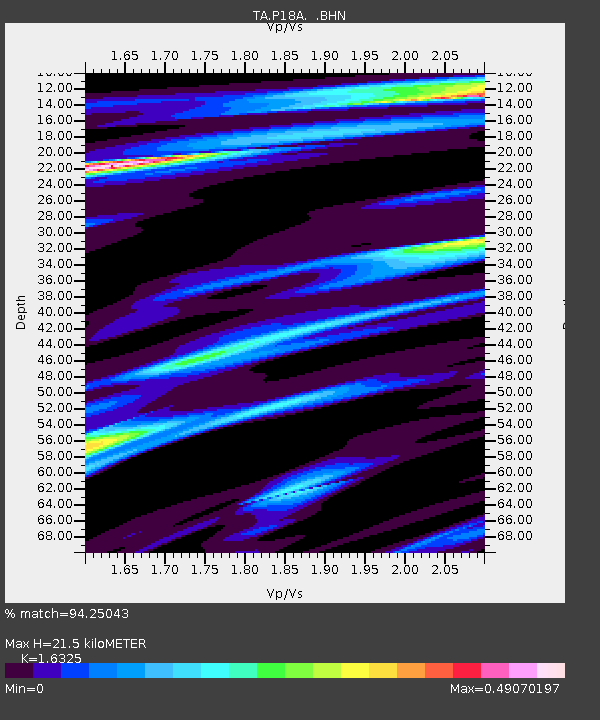
| Estimated Moho Depth: |
21.5 km |
| Estimated Crust Vp/Vs: |
1.63 |
| Assumed Crust Vp: |
6.207 km/s |
| Estimated Crust Vs: |
3.802 km/s |
| Estimated Crust Poisson's Ratio: |
0.20 |
|
| Radial Match: |
94.25043 % |
| Radial Bump: |
400 |
| Transverse Match: |
93.54801 % |
| Transverse Bump: |
400 |
| SOD ConfigId: |
2834 |
| Insert Time: |
2010-03-06 06:04:04.116 +0000 |
| GWidth: |
2.5 |
| Max Bumps: |
400 |
| Tol: |
0.001 |
|

Signal To Noise
| Channel | StoN | STA | LTA |
| TA:P18A: :BHN:20090115T17:59:45.874016Z | 28.91274 | 1.2514595E-5 | 4.3284012E-7 |
| TA:P18A: :BHE:20090115T17:59:45.874016Z | 7.2869787 | 3.4901275E-6 | 4.78954E-7 |
| TA:P18A: :BHZ:20090115T17:59:45.874016Z | 5.03838 | 2.9619966E-6 | 5.878867E-7 |
| Arrivals |
| Ps | 2.3 SECOND |
| PpPs | 8.7 SECOND |
| PsPs/PpSs | 11 SECOND |


