You are here: Home > Network List > TA - USArray Transportable Network (new EarthScope stations) Stations List
> Station D25K Kavik River, AK, USA > Earthquake Result Viewer
D25K Kavik River, AK, USA - Earthquake Result Viewer
*The percent match for this event was below the threshold and hence no stack was calculated.
| Earthquake location: |
Windward Islands |
| Earthquake latitude/longitude: |
11.7/-61.2 |
| Earthquake time(UTC): |
2017/11/05 (309) 15:00:24 GMT |
| Earthquake Depth: |
47 km |
| Earthquake Magnitude: |
5.5 Mww |
| Earthquake Catalog/Contributor: |
NEIC PDE/us |
|
| Network: |
TA USArray Transportable Network (new EarthScope stations) |
| Station: |
D25K Kavik River, AK, USA |
| Lat/Lon: |
69.32 N/146.38 W |
| Elevation: |
770 m |
|
| Distance: |
77.5 deg |
| Az: |
338.741 deg |
| Baz: |
90.31 deg |
| Ray Param: |
$rayparam |
*The percent match for this event was below the threshold and hence was not used in the summary stack. |
|
| Radial Match: |
49.17211 % |
| Radial Bump: |
400 |
| Transverse Match: |
61.385464 % |
| Transverse Bump: |
400 |
| SOD ConfigId: |
13570011 |
| Insert Time: |
2019-04-29 03:25:20.977 +0000 |
| GWidth: |
2.5 |
| Max Bumps: |
400 |
| Tol: |
0.001 |
|
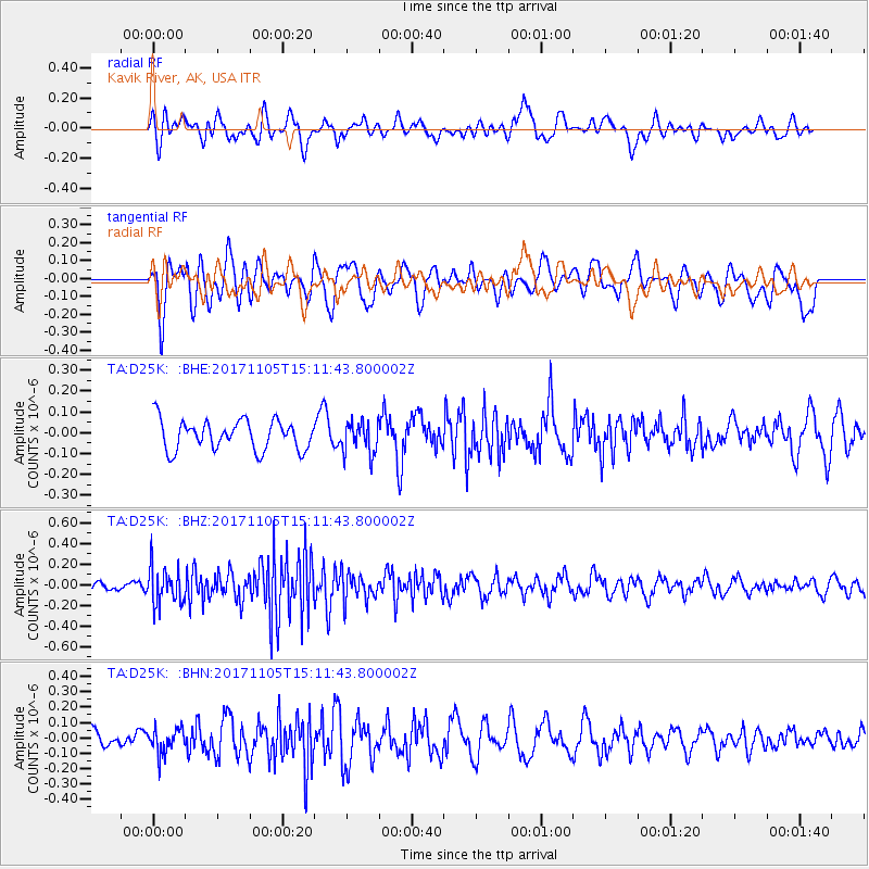
Signal To Noise
| Channel | StoN | STA | LTA |
| TA:D25K: :BHZ:20171105T15:11:43.800002Z | 3.1914852 | 1.82438E-7 | 5.716398E-8 |
| TA:D25K: :BHN:20171105T15:11:43.800002Z | 1.2532247 | 7.773453E-8 | 6.202761E-8 |
| TA:D25K: :BHE:20171105T15:11:43.800002Z | 1.0835071 | 7.6709284E-8 | 7.079721E-8 |
| Arrivals |
| Ps | |
| PpPs | |
| PsPs/PpSs | |


