You are here: Home > Network List > TA - USArray Transportable Network (new EarthScope stations) Stations List
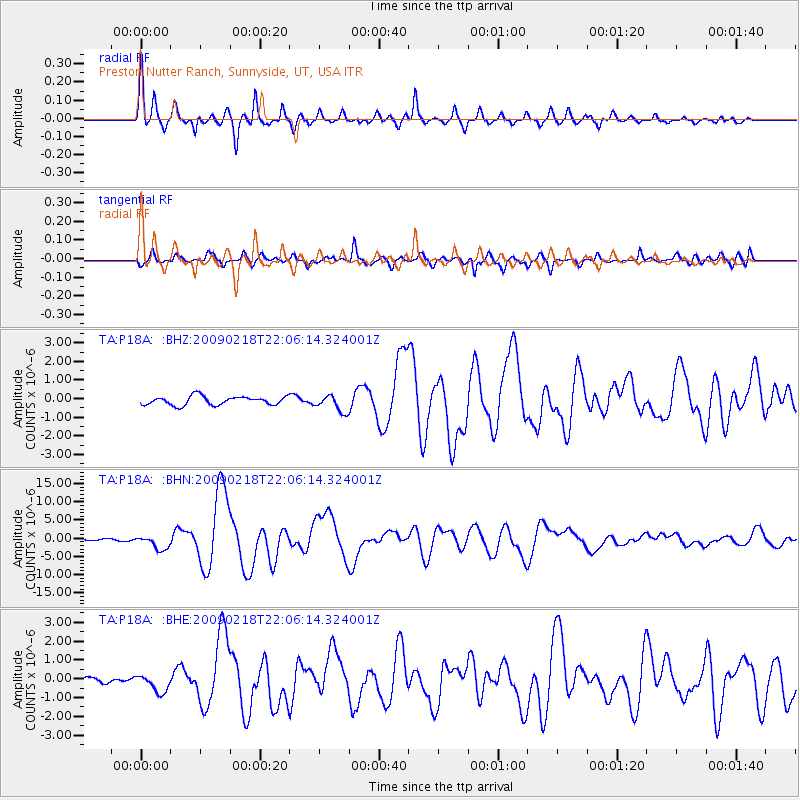
> Station P18A Preston Nutter Ranch, Sunnyside, UT, USA > Earthquake Result Viewer
P18A Preston Nutter Ranch, Sunnyside, UT, USA - Earthquake Result Viewer
| Earthquake location: |
Kermadec Islands Region |
| Earthquake latitude/longitude: |
-27.4/-176.3 |
| Earthquake time(UTC): |
2009/02/18 (049) 21:53:45 GMT |
| Earthquake Depth: |
25 km |
| Earthquake Magnitude: |
6.8 MB, 7.2 MS, 6.9 MW, 6.9 MW |
| Earthquake Catalog/Contributor: |
WHDF/NEIC |
|
| Network: |
TA USArray Transportable Network (new EarthScope stations) |
| Station: |
P18A Preston Nutter Ranch, Sunnyside, UT, USA |
| Lat/Lon: |
39.63 N/110.25 W |
| Elevation: |
2743 m |
|
| Distance: |
90.7 deg |
| Az: |
44.915 deg |
| Baz: |
234.354 deg |
| Ray Param: |
0.041650042 |
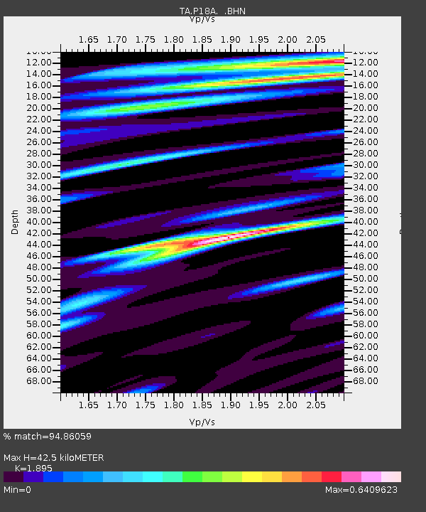
| Estimated Moho Depth: |
42.5 km |
| Estimated Crust Vp/Vs: |
1.89 |
| Assumed Crust Vp: |
6.207 km/s |
| Estimated Crust Vs: |
3.275 km/s |
| Estimated Crust Poisson's Ratio: |
0.31 |
|
| Radial Match: |
94.86059 % |
| Radial Bump: |
400 |
| Transverse Match: |
83.66088 % |
| Transverse Bump: |
400 |
| SOD ConfigId: |
2658 |
| Insert Time: |
2010-03-06 06:04:06.023 +0000 |
| GWidth: |
2.5 |
| Max Bumps: |
400 |
| Tol: |
0.001 |
|
Signal To Noise
| Channel | StoN | STA | LTA |
| TA:P18A: :BHN:20090218T22:06:14.324001Z | 13.462345 | 1.9090896E-6 | 1.418096E-7 |
| TA:P18A: :BHE:20090218T22:06:14.324001Z | 1.7070272 | 4.476657E-7 | 2.622487E-7 |
| TA:P18A: :BHZ:20090218T22:06:14.324001Z | 1.9390149 | 4.516772E-7 | 2.3294157E-7 |
| Arrivals |
| Ps | 6.2 SECOND |
| PpPs | 19 SECOND |
| PsPs/PpSs | 26 SECOND |


