You are here: Home > Network List > TA - USArray Transportable Network (new EarthScope stations) Stations List
> Station G31M Satah River, YT, CAN > Earthquake Result Viewer
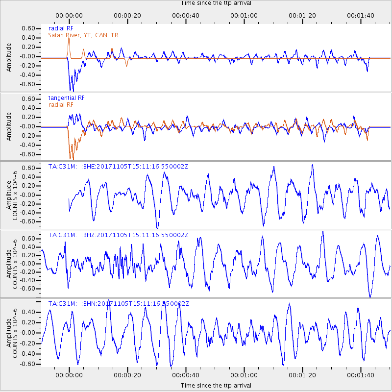
G31M Satah River, YT, CAN - Earthquake Result Viewer
*The percent match for this event was below the threshold and hence no stack was calculated.
| Earthquake location: |
Windward Islands |
| Earthquake latitude/longitude: |
11.7/-61.2 |
| Earthquake time(UTC): |
2017/11/05 (309) 15:00:24 GMT |
| Earthquake Depth: |
47 km |
| Earthquake Magnitude: |
5.5 Mww |
| Earthquake Catalog/Contributor: |
NEIC PDE/us |
|
| Network: |
TA USArray Transportable Network (new EarthScope stations) |
| Station: |
G31M Satah River, YT, CAN |
| Lat/Lon: |
66.92 N/134.27 W |
| Elevation: |
61 m |
|
| Distance: |
72.7 deg |
| Az: |
336.734 deg |
| Baz: |
101.024 deg |
| Ray Param: |
$rayparam |
*The percent match for this event was below the threshold and hence was not used in the summary stack. |
|
| Radial Match: |
64.4873 % |
| Radial Bump: |
400 |
| Transverse Match: |
41.40162 % |
| Transverse Bump: |
400 |
| SOD ConfigId: |
13570011 |
| Insert Time: |
2019-04-29 03:25:29.377 +0000 |
| GWidth: |
2.5 |
| Max Bumps: |
400 |
| Tol: |
0.001 |
|
Signal To Noise
| Channel | StoN | STA | LTA |
| TA:G31M: :BHZ:20171105T15:11:16.550002Z | 0.92854565 | 1.9509709E-7 | 2.1011039E-7 |
| TA:G31M: :BHN:20171105T15:11:16.550002Z | 1.3643064 | 3.1131185E-7 | 2.2818323E-7 |
| TA:G31M: :BHE:20171105T15:11:16.550002Z | 2.0944211 | 4.1373676E-7 | 1.9754228E-7 |
| Arrivals |
| Ps | |
| PpPs | |
| PsPs/PpSs | |


