You are here: Home > Network List > TA - USArray Transportable Network (new EarthScope stations) Stations List
> Station P18A Preston Nutter Ranch, Sunnyside, UT, USA > Earthquake Result Viewer
P18A Preston Nutter Ranch, Sunnyside, UT, USA - Earthquake Result Viewer
| Earthquake location: |
Peru-Ecuador Border Region |
| Earthquake latitude/longitude: |
-2.3/-77.8 |
| Earthquake time(UTC): |
2007/11/16 (320) 03:13:00 GMT |
| Earthquake Depth: |
123 km |
| Earthquake Magnitude: |
6.3 MB, 6.8 MW, 6.7 MW |
| Earthquake Catalog/Contributor: |
WHDF/NEIC |
|
| Network: |
TA USArray Transportable Network (new EarthScope stations) |
| Station: |
P18A Preston Nutter Ranch, Sunnyside, UT, USA |
| Lat/Lon: |
39.63 N/110.25 W |
| Elevation: |
2743 m |
|
| Distance: |
51.2 deg |
| Az: |
327.941 deg |
| Baz: |
136.628 deg |
| Ray Param: |
0.06713034 |
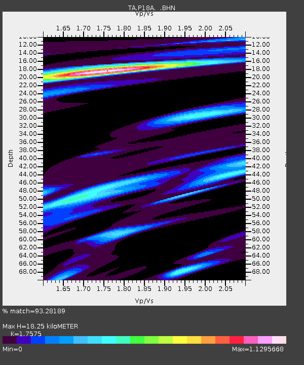
| Estimated Moho Depth: |
18.25 km |
| Estimated Crust Vp/Vs: |
1.76 |
| Assumed Crust Vp: |
6.207 km/s |
| Estimated Crust Vs: |
3.532 km/s |
| Estimated Crust Poisson's Ratio: |
0.26 |
|
| Radial Match: |
93.28189 % |
| Radial Bump: |
400 |
| Transverse Match: |
84.87503 % |
| Transverse Bump: |
400 |
| SOD ConfigId: |
2564 |
| Insert Time: |
2010-03-06 06:04:13.159 +0000 |
| GWidth: |
2.5 |
| Max Bumps: |
400 |
| Tol: |
0.001 |
|

Signal To Noise
| Channel | StoN | STA | LTA |
| TA:P18A: :BHN:20071116T03:21:20.648015Z | 3.8469539 | 5.490614E-7 | 1.4272626E-7 |
| TA:P18A: :BHE:20071116T03:21:20.648015Z | 3.7626042 | 5.402864E-7 | 1.4359375E-7 |
| TA:P18A: :BHZ:20071116T03:21:20.648015Z | 4.6197047 | 1.2053213E-6 | 2.6090873E-7 |
| Arrivals |
| Ps | 2.3 SECOND |
| PpPs | 7.7 SECOND |
| PsPs/PpSs | 10 SECOND |


