You are here: Home > Network List > TA - USArray Transportable Network (new EarthScope stations) Stations List
> Station P18A Preston Nutter Ranch, Sunnyside, UT, USA > Earthquake Result Viewer
P18A Preston Nutter Ranch, Sunnyside, UT, USA - Earthquake Result Viewer
| Earthquake location: |
Near Coast Of Peru |
| Earthquake latitude/longitude: |
-13.6/-76.6 |
| Earthquake time(UTC): |
2007/08/17 (229) 13:18:13 GMT |
| Earthquake Depth: |
48 km |
| Earthquake Magnitude: |
5.6 MB, 5.6 MS, 5.9 MW |
| Earthquake Catalog/Contributor: |
WHDF/NEIC |
|
| Network: |
TA USArray Transportable Network (new EarthScope stations) |
| Station: |
P18A Preston Nutter Ranch, Sunnyside, UT, USA |
| Lat/Lon: |
39.63 N/110.25 W |
| Elevation: |
2743 m |
|
| Distance: |
61.5 deg |
| Az: |
330.873 deg |
| Baz: |
142.208 deg |
| Ray Param: |
0.060709793 |
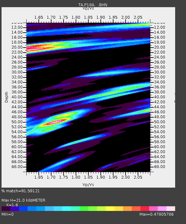
| Estimated Moho Depth: |
21.0 km |
| Estimated Crust Vp/Vs: |
1.60 |
| Assumed Crust Vp: |
6.207 km/s |
| Estimated Crust Vs: |
3.879 km/s |
| Estimated Crust Poisson's Ratio: |
0.18 |
|
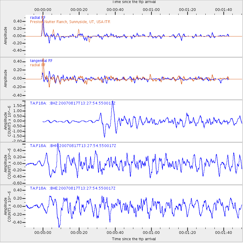
| Radial Match: |
91.59121 % |
| Radial Bump: |
400 |
| Transverse Match: |
80.09763 % |
| Transverse Bump: |
400 |
| SOD ConfigId: |
2564 |
| Insert Time: |
2010-03-06 06:04:27.558 +0000 |
| GWidth: |
2.5 |
| Max Bumps: |
400 |
| Tol: |
0.001 |
|
Signal To Noise
| Channel | StoN | STA | LTA |
| TA:P18A: :BHN:20070817T13:27:54.550017Z | 4.226568 | 2.1134021E-7 | 5.000279E-8 |
| TA:P18A: :BHE:20070817T13:27:54.550017Z | 3.9191046 | 1.4014822E-7 | 3.5760266E-8 |
| TA:P18A: :BHZ:20070817T13:27:54.550017Z | 10.036077 | 6.3589056E-7 | 6.3360474E-8 |
| Arrivals |
| Ps | 2.1 SECOND |
| PpPs | 8.4 SECOND |
| PsPs/PpSs | 11 SECOND |


